You are here: Home > Network List > AK - Alaska Regional Network Stations List
> Station BCP Bancas Point, AK, USA > Earthquake Result Viewer
BCP Bancas Point, AK, USA - Earthquake Result Viewer
| Earthquake location: |
Solomon Islands |
| Earthquake latitude/longitude: |
-6.5/154.5 |
| Earthquake time(UTC): |
2014/12/07 (341) 01:22:00 GMT |
| Earthquake Depth: |
10 km |
| Earthquake Magnitude: |
6.8 MWP, 6.7 MI, 6.8 MI |
| Earthquake Catalog/Contributor: |
NEIC PDE/NEIC COMCAT |
|
| Network: |
AK Alaska Regional Network |
| Station: |
BCP Bancas Point, AK, USA |
| Lat/Lon: |
59.95 N/139.63 W |
| Elevation: |
422 m |
|
| Distance: |
83.9 deg |
| Az: |
27.517 deg |
| Baz: |
245.815 deg |
| Ray Param: |
0.04586247 |
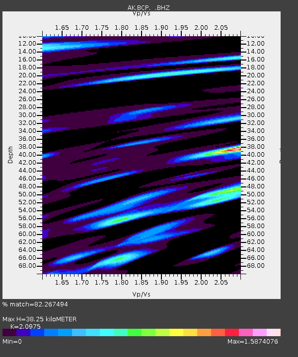
| Estimated Moho Depth: |
38.25 km |
| Estimated Crust Vp/Vs: |
2.10 |
| Assumed Crust Vp: |
6.183 km/s |
| Estimated Crust Vs: |
2.948 km/s |
| Estimated Crust Poisson's Ratio: |
0.35 |
|
| Radial Match: |
82.267494 % |
| Radial Bump: |
400 |
| Transverse Match: |
71.92392 % |
| Transverse Bump: |
400 |
| SOD ConfigId: |
822761 |
| Insert Time: |
2014-12-21 01:24:48.766 +0000 |
| GWidth: |
2.5 |
| Max Bumps: |
400 |
| Tol: |
0.001 |
|

Signal To Noise
| Channel | StoN | STA | LTA |
| AK:BCP: :BHZ:20141207T01:33:59.14803Z | 4.673597 | 1.1846819E-6 | 2.5348396E-7 |
| AK:BCP: :BHN:20141207T01:33:59.14803Z | 2.1932094 | 6.4715823E-7 | 2.9507362E-7 |
| AK:BCP: :BHE:20141207T01:33:59.14803Z | 2.9485898 | 8.720038E-7 | 2.9573587E-7 |
| Arrivals |
| Ps | 6.9 SECOND |
| PpPs | 19 SECOND |
| PsPs/PpSs | 26 SECOND |


