You are here: Home > Network List > AK - Alaska Regional Network Stations List
> Station JIS Juneau Island, AK, USA > Earthquake Result Viewer
JIS Juneau Island, AK, USA - Earthquake Result Viewer
| Earthquake location: |
Solomon Islands |
| Earthquake latitude/longitude: |
-6.5/154.5 |
| Earthquake time(UTC): |
2014/12/07 (341) 01:22:00 GMT |
| Earthquake Depth: |
10 km |
| Earthquake Magnitude: |
6.8 MWP, 6.7 MI, 6.8 MI |
| Earthquake Catalog/Contributor: |
NEIC PDE/NEIC COMCAT |
|
| Network: |
AK Alaska Regional Network |
| Station: |
JIS Juneau Island, AK, USA |
| Lat/Lon: |
58.28 N/134.38 W |
| Elevation: |
10 m |
|
| Distance: |
85.8 deg |
| Az: |
30.095 deg |
| Baz: |
250.547 deg |
| Ray Param: |
0.044515368 |
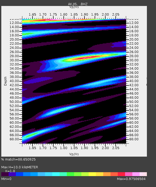
| Estimated Moho Depth: |
10.0 km |
| Estimated Crust Vp/Vs: |
1.80 |
| Assumed Crust Vp: |
6.566 km/s |
| Estimated Crust Vs: |
3.648 km/s |
| Estimated Crust Poisson's Ratio: |
0.28 |
|
| Radial Match: |
88.650925 % |
| Radial Bump: |
400 |
| Transverse Match: |
71.85516 % |
| Transverse Bump: |
400 |
| SOD ConfigId: |
822761 |
| Insert Time: |
2014-12-21 01:26:03.988 +0000 |
| GWidth: |
2.5 |
| Max Bumps: |
400 |
| Tol: |
0.001 |
|

Signal To Noise
| Channel | StoN | STA | LTA |
| AK:JIS: :BHZ:20141207T01:34:08.62801Z | 4.9979625 | 1.0400379E-6 | 2.0809237E-7 |
| AK:JIS: :BHN:20141207T01:34:08.62801Z | 1.2294108 | 1.7795529E-7 | 1.4474843E-7 |
| AK:JIS: :BHE:20141207T01:34:08.62801Z | 3.33954 | 4.195889E-7 | 1.2564273E-7 |
| Arrivals |
| Ps | 1.2 SECOND |
| PpPs | 4.2 SECOND |
| PsPs/PpSs | 5.4 SECOND |


