You are here: Home > Network List > TA - USArray Transportable Network (new EarthScope stations) Stations List
> Station G60A Masonville, QC, CAN > Earthquake Result Viewer
G60A Masonville, QC, CAN - Earthquake Result Viewer
| Earthquake location: |
Near East Coast Of Honshu, Japan |
| Earthquake latitude/longitude: |
38.9/142.0 |
| Earthquake time(UTC): |
2015/05/12 (132) 21:12:58 GMT |
| Earthquake Depth: |
39 km |
| Earthquake Magnitude: |
6.8 MWP, 6.8 MI |
| Earthquake Catalog/Contributor: |
NEIC PDE/NEIC COMCAT |
|
| Network: |
TA USArray Transportable Network (new EarthScope stations) |
| Station: |
G60A Masonville, QC, CAN |
| Lat/Lon: |
45.10 N/72.33 W |
| Elevation: |
391 m |
|
| Distance: |
90.8 deg |
| Az: |
23.569 deg |
| Baz: |
333.864 deg |
| Ray Param: |
0.04163944 |
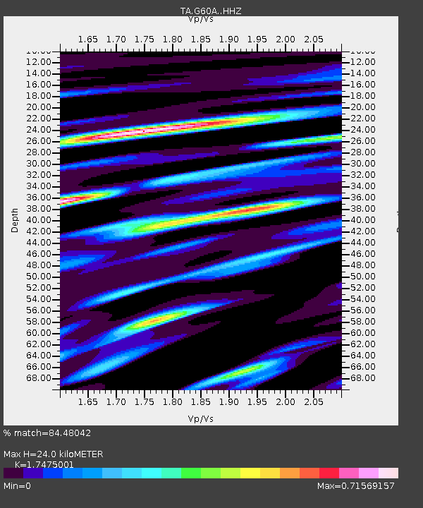
| Estimated Moho Depth: |
24.0 km |
| Estimated Crust Vp/Vs: |
1.75 |
| Assumed Crust Vp: |
6.419 km/s |
| Estimated Crust Vs: |
3.673 km/s |
| Estimated Crust Poisson's Ratio: |
0.26 |
|
| Radial Match: |
84.48042 % |
| Radial Bump: |
398 |
| Transverse Match: |
61.007492 % |
| Transverse Bump: |
389 |
| SOD ConfigId: |
7422571 |
| Insert Time: |
2019-04-18 20:50:01.930 +0000 |
| GWidth: |
2.5 |
| Max Bumps: |
400 |
| Tol: |
0.001 |
|
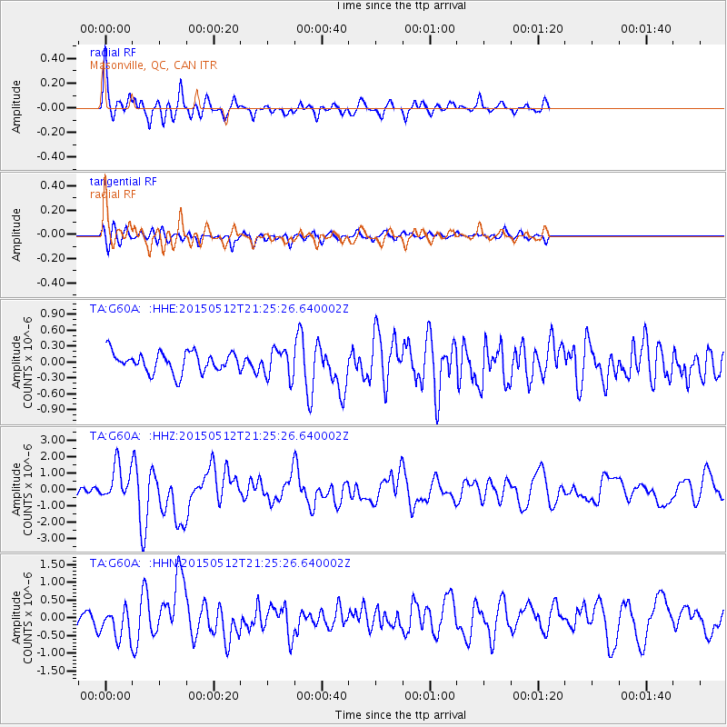
Signal To Noise
| Channel | StoN | STA | LTA |
| TA:G60A: :HHZ:20150512T21:25:26.640002Z | 3.8608277 | 1.1330984E-6 | 2.9348587E-7 |
| TA:G60A: :HHN:20150512T21:25:26.640002Z | 2.498807 | 4.471201E-7 | 1.7893342E-7 |
| TA:G60A: :HHE:20150512T21:25:26.640002Z | 1.5134879 | 2.8053964E-7 | 1.8535968E-7 |
| Arrivals |
| Ps | 2.9 SECOND |
| PpPs | 10 SECOND |
| PsPs/PpSs | 13 SECOND |


