You are here: Home > Network List > TA - USArray Transportable Network (new EarthScope stations) Stations List
> Station G61A St-Isidore-de-Clifton, QC, USA > Earthquake Result Viewer
G61A St-Isidore-de-Clifton, QC, USA - Earthquake Result Viewer
| Earthquake location: |
Near East Coast Of Honshu, Japan |
| Earthquake latitude/longitude: |
38.9/142.0 |
| Earthquake time(UTC): |
2015/05/12 (132) 21:12:58 GMT |
| Earthquake Depth: |
39 km |
| Earthquake Magnitude: |
6.8 MWP, 6.8 MI |
| Earthquake Catalog/Contributor: |
NEIC PDE/NEIC COMCAT |
|
| Network: |
TA USArray Transportable Network (new EarthScope stations) |
| Station: |
G61A St-Isidore-de-Clifton, QC, USA |
| Lat/Lon: |
45.28 N/71.53 W |
| Elevation: |
378 m |
|
| Distance: |
90.9 deg |
| Az: |
22.975 deg |
| Baz: |
334.444 deg |
| Ray Param: |
0.041633584 |
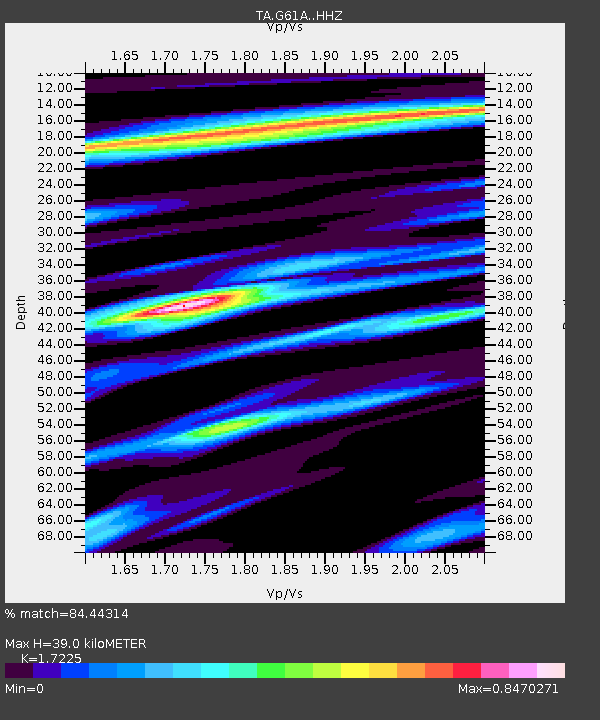
| Estimated Moho Depth: |
39.0 km |
| Estimated Crust Vp/Vs: |
1.72 |
| Assumed Crust Vp: |
6.419 km/s |
| Estimated Crust Vs: |
3.727 km/s |
| Estimated Crust Poisson's Ratio: |
0.25 |
|
| Radial Match: |
84.44314 % |
| Radial Bump: |
280 |
| Transverse Match: |
70.17101 % |
| Transverse Bump: |
400 |
| SOD ConfigId: |
7422571 |
| Insert Time: |
2019-04-18 20:50:02.092 +0000 |
| GWidth: |
2.5 |
| Max Bumps: |
400 |
| Tol: |
0.001 |
|
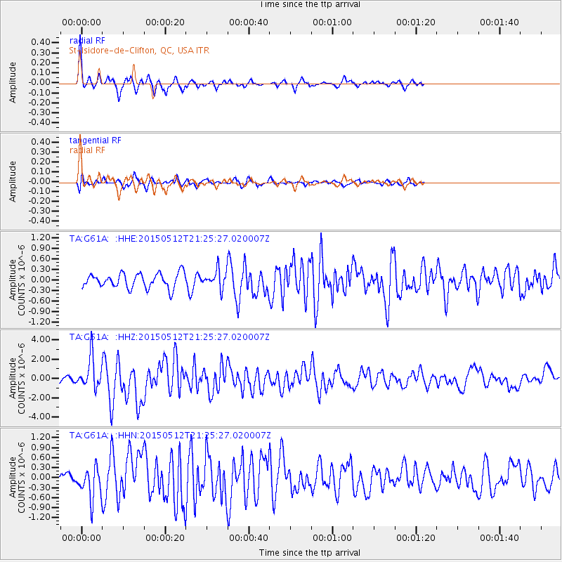
Signal To Noise
| Channel | StoN | STA | LTA |
| TA:G61A: :HHZ:20150512T21:25:27.020007Z | 6.267513 | 1.6662552E-6 | 2.658559E-7 |
| TA:G61A: :HHN:20150512T21:25:27.020007Z | 2.2518945 | 4.947411E-7 | 2.1969993E-7 |
| TA:G61A: :HHE:20150512T21:25:27.020007Z | 1.6523619 | 3.397119E-7 | 2.0559172E-7 |
| Arrivals |
| Ps | 4.5 SECOND |
| PpPs | 16 SECOND |
| PsPs/PpSs | 21 SECOND |


