You are here: Home > Network List > TA - USArray Transportable Network (new EarthScope stations) Stations List
> Station G63A Kingsbury, ME, USA > Earthquake Result Viewer
G63A Kingsbury, ME, USA - Earthquake Result Viewer
| Earthquake location: |
Near East Coast Of Honshu, Japan |
| Earthquake latitude/longitude: |
38.9/142.0 |
| Earthquake time(UTC): |
2015/05/12 (132) 21:12:58 GMT |
| Earthquake Depth: |
39 km |
| Earthquake Magnitude: |
6.8 MWP, 6.8 MI |
| Earthquake Catalog/Contributor: |
NEIC PDE/NEIC COMCAT |
|
| Network: |
TA USArray Transportable Network (new EarthScope stations) |
| Station: |
G63A Kingsbury, ME, USA |
| Lat/Lon: |
45.11 N/69.62 W |
| Elevation: |
363 m |
|
| Distance: |
91.6 deg |
| Az: |
21.821 deg |
| Baz: |
335.819 deg |
| Ray Param: |
0.04156766 |
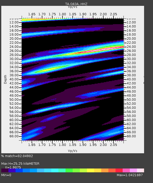
| Estimated Moho Depth: |
25.25 km |
| Estimated Crust Vp/Vs: |
1.99 |
| Assumed Crust Vp: |
6.419 km/s |
| Estimated Crust Vs: |
3.23 km/s |
| Estimated Crust Poisson's Ratio: |
0.33 |
|
| Radial Match: |
82.84982 % |
| Radial Bump: |
272 |
| Transverse Match: |
66.73653 % |
| Transverse Bump: |
369 |
| SOD ConfigId: |
7422571 |
| Insert Time: |
2019-04-18 20:50:02.178 +0000 |
| GWidth: |
2.5 |
| Max Bumps: |
400 |
| Tol: |
0.001 |
|

Signal To Noise
| Channel | StoN | STA | LTA |
| TA:G63A: :HHZ:20150512T21:25:30.340015Z | 4.980747 | 1.2462983E-6 | 2.5022314E-7 |
| TA:G63A: :HHN:20150512T21:25:30.340015Z | 1.8811027 | 3.8944637E-7 | 2.070309E-7 |
| TA:G63A: :HHE:20150512T21:25:30.340015Z | 1.4119625 | 2.824442E-7 | 2.0003661E-7 |
| Arrivals |
| Ps | 4.0 SECOND |
| PpPs | 12 SECOND |
| PsPs/PpSs | 15 SECOND |


