You are here: Home > Network List > TA - USArray Transportable Network (new EarthScope stations) Stations List
> Station J05D Fort Rock, OR, USA > Earthquake Result Viewer
J05D Fort Rock, OR, USA - Earthquake Result Viewer

| Earthquake location: |
Near East Coast Of Honshu, Japan |
| Earthquake latitude/longitude: |
38.9/142.0 |
| Earthquake time(UTC): |
2015/05/12 (132) 21:12:58 GMT |
| Earthquake Depth: |
39 km |
| Earthquake Magnitude: |
6.8 MWP, 6.8 MI |
| Earthquake Catalog/Contributor: |
NEIC PDE/NEIC COMCAT |
|
| Network: |
TA USArray Transportable Network (new EarthScope stations) |
| Station: |
J05D Fort Rock, OR, USA |
| Lat/Lon: |
43.28 N/121.23 W |
| Elevation: |
1541 m |
|
| Distance: |
68.9 deg |
| Az: |
51.031 deg |
| Baz: |
303.824 deg |
| Ray Param: |
0.055954266 |
| Estimated Moho Depth: |
51.5 km |
| Estimated Crust Vp/Vs: |
1.60 |
| Assumed Crust Vp: |
6.597 km/s |
| Estimated Crust Vs: |
4.123 km/s |
| Estimated Crust Poisson's Ratio: |
0.18 |
|
| Radial Match: |
89.59309 % |
| Radial Bump: |
400 |
| Transverse Match: |
84.42098 % |
| Transverse Bump: |
400 |
| SOD ConfigId: |
7422571 |
| Insert Time: |
2019-04-18 20:50:28.186 +0000 |
| GWidth: |
2.5 |
| Max Bumps: |
400 |
| Tol: |
0.001 |
|
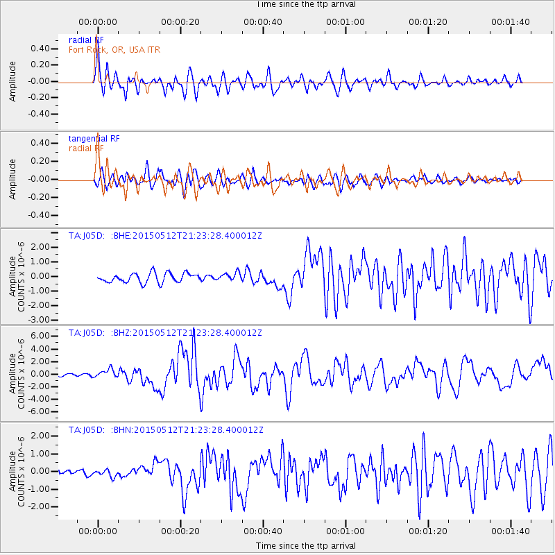
Signal To Noise
| Channel | StoN | STA | LTA |
| TA:J05D: :BHZ:20150512T21:23:28.400012Z | 2.7509184 | 6.6349253E-7 | 2.4118944E-7 |
| TA:J05D: :BHN:20150512T21:23:28.400012Z | 1.0323406 | 1.9193645E-7 | 1.8592357E-7 |
| TA:J05D: :BHE:20150512T21:23:28.400012Z | 0.89281064 | 2.912999E-7 | 3.2627287E-7 |
| Arrivals |
| Ps | 4.9 SECOND |
| PpPs | 19 SECOND |
| PsPs/PpSs | 24 SECOND |


