You are here: Home > Network List > TA - USArray Transportable Network (new EarthScope stations) Stations List
> Station L59A Walton, NY, USA > Earthquake Result Viewer
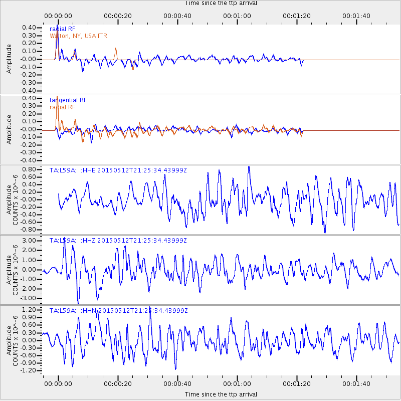
L59A Walton, NY, USA - Earthquake Result Viewer
*The percent match for this event was below the threshold and hence no stack was calculated.
| Earthquake location: |
Near East Coast Of Honshu, Japan |
| Earthquake latitude/longitude: |
38.9/142.0 |
| Earthquake time(UTC): |
2015/05/12 (132) 21:12:58 GMT |
| Earthquake Depth: |
39 km |
| Earthquake Magnitude: |
6.8 MWP, 6.8 MI |
| Earthquake Catalog/Contributor: |
NEIC PDE/NEIC COMCAT |
|
| Network: |
TA USArray Transportable Network (new EarthScope stations) |
| Station: |
L59A Walton, NY, USA |
| Lat/Lon: |
42.19 N/75.04 W |
| Elevation: |
677 m |
|
| Distance: |
92.5 deg |
| Az: |
26.645 deg |
| Baz: |
331.91 deg |
| Ray Param: |
$rayparam |
*The percent match for this event was below the threshold and hence was not used in the summary stack. |
|
| Radial Match: |
78.071014 % |
| Radial Bump: |
318 |
| Transverse Match: |
70.13497 % |
| Transverse Bump: |
400 |
| SOD ConfigId: |
7422571 |
| Insert Time: |
2019-04-18 20:50:50.613 +0000 |
| GWidth: |
2.5 |
| Max Bumps: |
400 |
| Tol: |
0.001 |
|
Signal To Noise
| Channel | StoN | STA | LTA |
| TA:L59A: :HHZ:20150512T21:25:34.43999Z | 6.7905917 | 1.2945371E-6 | 1.9063687E-7 |
| TA:L59A: :HHN:20150512T21:25:34.43999Z | 1.9505929 | 4.1298267E-7 | 2.1172161E-7 |
| TA:L59A: :HHE:20150512T21:25:34.43999Z | 1.4153143 | 2.7982642E-7 | 1.9771328E-7 |
| Arrivals |
| Ps | |
| PpPs | |
| PsPs/PpSs | |


