You are here: Home > Network List > TA - USArray Transportable Network (new EarthScope stations) Stations List
> Station M57A Sunshine Farm, Cogan Station, PA, USA > Earthquake Result Viewer
M57A Sunshine Farm, Cogan Station, PA, USA - Earthquake Result Viewer
| Earthquake location: |
Near East Coast Of Honshu, Japan |
| Earthquake latitude/longitude: |
38.9/142.0 |
| Earthquake time(UTC): |
2015/05/12 (132) 21:12:58 GMT |
| Earthquake Depth: |
39 km |
| Earthquake Magnitude: |
6.8 MWP, 6.8 MI |
| Earthquake Catalog/Contributor: |
NEIC PDE/NEIC COMCAT |
|
| Network: |
TA USArray Transportable Network (new EarthScope stations) |
| Station: |
M57A Sunshine Farm, Cogan Station, PA, USA |
| Lat/Lon: |
41.34 N/77.13 W |
| Elevation: |
319 m |
|
| Distance: |
92.5 deg |
| Az: |
28.424 deg |
| Baz: |
330.448 deg |
| Ray Param: |
0.041426722 |
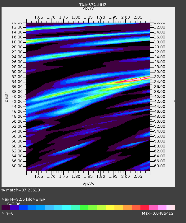
| Estimated Moho Depth: |
32.5 km |
| Estimated Crust Vp/Vs: |
2.06 |
| Assumed Crust Vp: |
6.121 km/s |
| Estimated Crust Vs: |
2.971 km/s |
| Estimated Crust Poisson's Ratio: |
0.35 |
|
| Radial Match: |
87.23613 % |
| Radial Bump: |
400 |
| Transverse Match: |
58.24029 % |
| Transverse Bump: |
400 |
| SOD ConfigId: |
7422571 |
| Insert Time: |
2019-04-18 20:51:02.216 +0000 |
| GWidth: |
2.5 |
| Max Bumps: |
400 |
| Tol: |
0.001 |
|
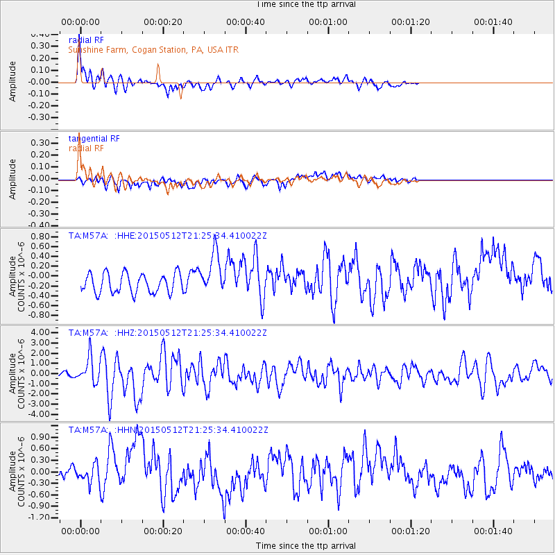
Signal To Noise
| Channel | StoN | STA | LTA |
| TA:M57A: :HHZ:20150512T21:25:34.410022Z | 4.1539907 | 1.3363347E-6 | 3.2169902E-7 |
| TA:M57A: :HHN:20150512T21:25:34.410022Z | 1.662217 | 2.548055E-7 | 1.5329258E-7 |
| TA:M57A: :HHE:20150512T21:25:34.410022Z | 2.2763677 | 4.4679365E-7 | 1.9627481E-7 |
| Arrivals |
| Ps | 5.7 SECOND |
| PpPs | 16 SECOND |
| PsPs/PpSs | 22 SECOND |


