You are here: Home > Network List > TA - USArray Transportable Network (new EarthScope stations) Stations List
> Station N58A Sunbury, PA, USA > Earthquake Result Viewer
N58A Sunbury, PA, USA - Earthquake Result Viewer
| Earthquake location: |
Near East Coast Of Honshu, Japan |
| Earthquake latitude/longitude: |
38.9/142.0 |
| Earthquake time(UTC): |
2015/05/12 (132) 21:12:58 GMT |
| Earthquake Depth: |
39 km |
| Earthquake Magnitude: |
6.8 MWP, 6.8 MI |
| Earthquake Catalog/Contributor: |
NEIC PDE/NEIC COMCAT |
|
| Network: |
TA USArray Transportable Network (new EarthScope stations) |
| Station: |
N58A Sunbury, PA, USA |
| Lat/Lon: |
40.84 N/76.72 W |
| Elevation: |
200 m |
|
| Distance: |
93.1 deg |
| Az: |
28.397 deg |
| Baz: |
330.719 deg |
| Ray Param: |
0.04131087 |
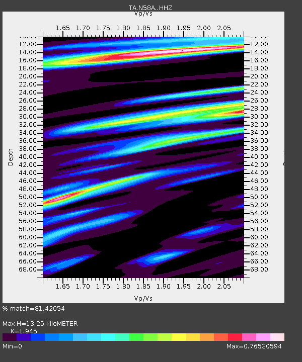
| Estimated Moho Depth: |
13.25 km |
| Estimated Crust Vp/Vs: |
1.95 |
| Assumed Crust Vp: |
6.121 km/s |
| Estimated Crust Vs: |
3.147 km/s |
| Estimated Crust Poisson's Ratio: |
0.32 |
|
| Radial Match: |
81.42054 % |
| Radial Bump: |
361 |
| Transverse Match: |
73.286964 % |
| Transverse Bump: |
400 |
| SOD ConfigId: |
7422571 |
| Insert Time: |
2019-04-18 20:51:10.936 +0000 |
| GWidth: |
2.5 |
| Max Bumps: |
400 |
| Tol: |
0.001 |
|

Signal To Noise
| Channel | StoN | STA | LTA |
| TA:N58A: :HHZ:20150512T21:25:37.109973Z | 6.2310286 | 1.020663E-6 | 1.638033E-7 |
| TA:N58A: :HHN:20150512T21:25:37.109973Z | 2.3445723 | 3.0182576E-7 | 1.2873383E-7 |
| TA:N58A: :HHE:20150512T21:25:37.109973Z | 1.869198 | 1.9878132E-7 | 1.0634578E-7 |
| Arrivals |
| Ps | 2.1 SECOND |
| PpPs | 6.3 SECOND |
| PsPs/PpSs | 8.3 SECOND |


