You are here: Home > Network List > TA - USArray Transportable Network (new EarthScope stations) Stations List
> Station N60A Cedar Hill Farm, Mount Bethel, PA, USA > Earthquake Result Viewer
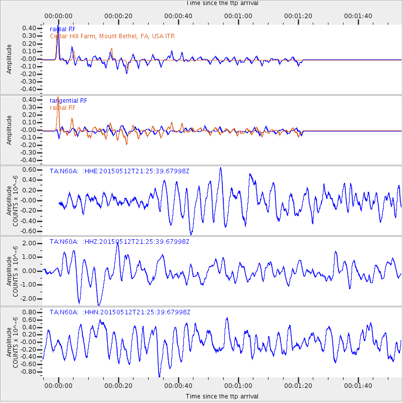
N60A Cedar Hill Farm, Mount Bethel, PA, USA - Earthquake Result Viewer
| Earthquake location: |
Near East Coast Of Honshu, Japan |
| Earthquake latitude/longitude: |
38.9/142.0 |
| Earthquake time(UTC): |
2015/05/12 (132) 21:12:58 GMT |
| Earthquake Depth: |
39 km |
| Earthquake Magnitude: |
6.8 MWP, 6.8 MI |
| Earthquake Catalog/Contributor: |
NEIC PDE/NEIC COMCAT |
|
| Network: |
TA USArray Transportable Network (new EarthScope stations) |
| Station: |
N60A Cedar Hill Farm, Mount Bethel, PA, USA |
| Lat/Lon: |
40.87 N/75.10 W |
| Elevation: |
189 m |
|
| Distance: |
93.7 deg |
| Az: |
27.305 deg |
| Baz: |
331.836 deg |
| Ray Param: |
0.041199766 |
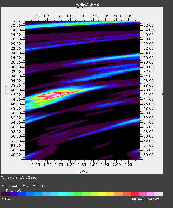
| Estimated Moho Depth: |
41.75 km |
| Estimated Crust Vp/Vs: |
1.75 |
| Assumed Crust Vp: |
6.283 km/s |
| Estimated Crust Vs: |
3.58 km/s |
| Estimated Crust Poisson's Ratio: |
0.26 |
|
| Radial Match: |
85.12997 % |
| Radial Bump: |
289 |
| Transverse Match: |
62.42728 % |
| Transverse Bump: |
301 |
| SOD ConfigId: |
7422571 |
| Insert Time: |
2019-04-18 20:51:11.929 +0000 |
| GWidth: |
2.5 |
| Max Bumps: |
400 |
| Tol: |
0.001 |
|
Signal To Noise
| Channel | StoN | STA | LTA |
| TA:N60A: :HHZ:20150512T21:25:39.67998Z | 5.648904 | 7.570352E-7 | 1.3401453E-7 |
| TA:N60A: :HHN:20150512T21:25:39.67998Z | 1.349136 | 2.3696082E-7 | 1.7563895E-7 |
| TA:N60A: :HHE:20150512T21:25:39.67998Z | 1.9830352 | 1.6781928E-7 | 8.462748E-8 |
| Arrivals |
| Ps | 5.1 SECOND |
| PpPs | 18 SECOND |
| PsPs/PpSs | 23 SECOND |


