You are here: Home > Network List > TM - Thai Seismic Monitoring Network Stations List
> Station UBPT UBPT Phase1 > Earthquake Result Viewer
UBPT UBPT Phase1 - Earthquake Result Viewer
| Earthquake location: |
Near East Coast Of Honshu, Japan |
| Earthquake latitude/longitude: |
38.9/142.0 |
| Earthquake time(UTC): |
2015/05/12 (132) 21:12:58 GMT |
| Earthquake Depth: |
39 km |
| Earthquake Magnitude: |
6.8 MWP, 6.8 MI |
| Earthquake Catalog/Contributor: |
NEIC PDE/NEIC COMCAT |
|
| Network: |
TM Thai Seismic Monitoring Network |
| Station: |
UBPT UBPT Phase1 |
| Lat/Lon: |
15.28 N/105.47 E |
| Elevation: |
120 m |
|
| Distance: |
39.8 deg |
| Az: |
243.992 deg |
| Baz: |
46.603 deg |
| Ray Param: |
0.07470255 |
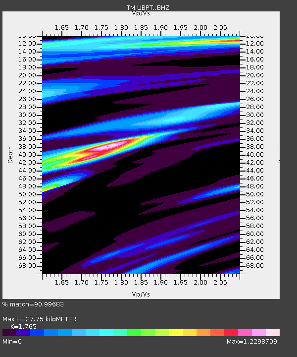
| Estimated Moho Depth: |
37.75 km |
| Estimated Crust Vp/Vs: |
1.76 |
| Assumed Crust Vp: |
6.444 km/s |
| Estimated Crust Vs: |
3.651 km/s |
| Estimated Crust Poisson's Ratio: |
0.26 |
|
| Radial Match: |
90.99683 % |
| Radial Bump: |
299 |
| Transverse Match: |
88.28871 % |
| Transverse Bump: |
377 |
| SOD ConfigId: |
7422571 |
| Insert Time: |
2019-04-18 20:51:44.782 +0000 |
| GWidth: |
2.5 |
| Max Bumps: |
400 |
| Tol: |
0.001 |
|

Signal To Noise
| Channel | StoN | STA | LTA |
| TM:UBPT: :BHZ:20150512T21:19:57.150012Z | 42.561897 | 4.4528947E-6 | 1.0462162E-7 |
| TM:UBPT: :BHN:20150512T21:19:57.150012Z | 5.6260376 | 2.0054858E-6 | 3.5646502E-7 |
| TM:UBPT: :BHE:20150512T21:19:57.150012Z | 3.5377192 | 1.0115069E-6 | 2.8592063E-7 |
| Arrivals |
| Ps | 4.8 SECOND |
| PpPs | 15 SECOND |
| PsPs/PpSs | 20 SECOND |


