You are here: Home > Network List > TW - Broadband Array in Taiwan for Seismology Stations List
> Station VNAS Nansha Is. > Earthquake Result Viewer
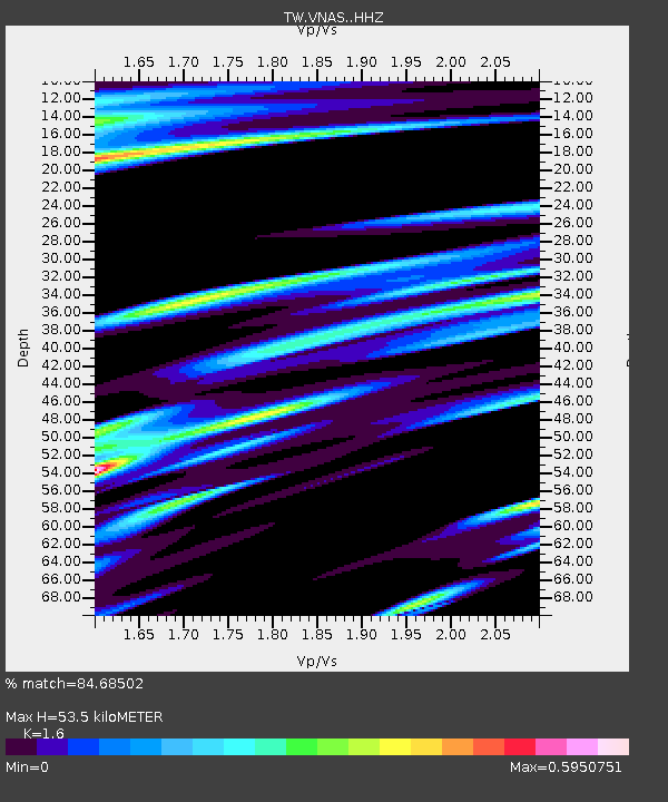
VNAS Nansha Is. - Earthquake Result Viewer
| Earthquake location: |
Near East Coast Of Honshu, Japan |
| Earthquake latitude/longitude: |
38.9/142.0 |
| Earthquake time(UTC): |
2015/05/12 (132) 21:12:58 GMT |
| Earthquake Depth: |
39 km |
| Earthquake Magnitude: |
6.8 MWP, 6.8 MI |
| Earthquake Catalog/Contributor: |
NEIC PDE/NEIC COMCAT |
|
| Network: |
TW Broadband Array in Taiwan for Seismology |
| Station: |
VNAS Nansha Is. |
| Lat/Lon: |
10.38 N/114.36 E |
| Elevation: |
2.0 m |
|
| Distance: |
37.6 deg |
| Az: |
228.419 deg |
| Baz: |
36.387 deg |
| Ray Param: |
0.07593591 |
| Estimated Moho Depth: |
53.5 km |
| Estimated Crust Vp/Vs: |
1.60 |
| Assumed Crust Vp: |
6.183 km/s |
| Estimated Crust Vs: |
3.864 km/s |
| Estimated Crust Poisson's Ratio: |
0.18 |
|
| Radial Match: |
84.68502 % |
| Radial Bump: |
338 |
| Transverse Match: |
67.87072 % |
| Transverse Bump: |
352 |
| SOD ConfigId: |
7422571 |
| Insert Time: |
2019-04-18 20:52:01.907 +0000 |
| GWidth: |
2.5 |
| Max Bumps: |
400 |
| Tol: |
0.001 |
|

Signal To Noise
| Channel | StoN | STA | LTA |
| TW:VNAS: :HHZ:20150512T21:19:39.370013Z | 24.283237 | 5.0829003E-6 | 2.0931725E-7 |
| TW:VNAS: :HHN:20150512T21:19:39.370013Z | 10.167407 | 2.0921239E-6 | 2.0576769E-7 |
| TW:VNAS: :HHE:20150512T21:19:39.370013Z | 7.810922 | 1.5267493E-6 | 1.9546339E-7 |
| Arrivals |
| Ps | 5.6 SECOND |
| PpPs | 21 SECOND |
| PsPs/PpSs | 26 SECOND |


