You are here: Home > Network List > UW - Pacific Northwest Regional Seismic Network Stations List
> Station IZEE Izee, OR, USA > Earthquake Result Viewer
IZEE Izee, OR, USA - Earthquake Result Viewer
| Earthquake location: |
Near East Coast Of Honshu, Japan |
| Earthquake latitude/longitude: |
38.9/142.0 |
| Earthquake time(UTC): |
2015/05/12 (132) 21:12:58 GMT |
| Earthquake Depth: |
39 km |
| Earthquake Magnitude: |
6.8 MWP, 6.8 MI |
| Earthquake Catalog/Contributor: |
NEIC PDE/NEIC COMCAT |
|
| Network: |
UW Pacific Northwest Regional Seismic Network |
| Station: |
IZEE Izee, OR, USA |
| Lat/Lon: |
44.08 N/119.50 W |
| Elevation: |
1293 m |
|
| Distance: |
69.5 deg |
| Az: |
49.571 deg |
| Baz: |
304.496 deg |
| Ray Param: |
0.0555647 |
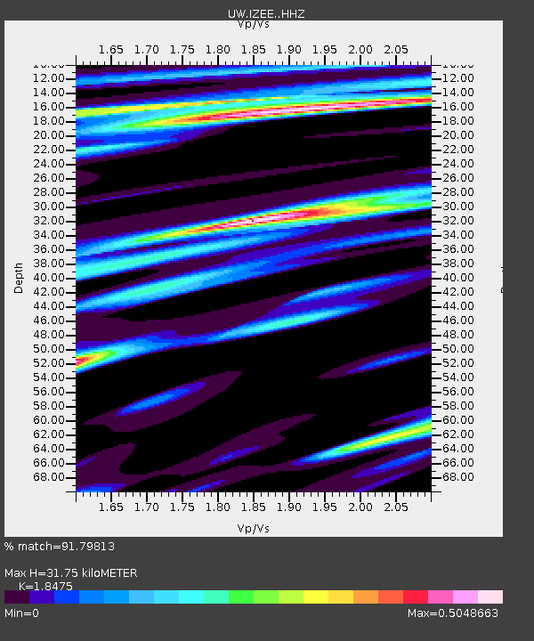
| Estimated Moho Depth: |
31.75 km |
| Estimated Crust Vp/Vs: |
1.85 |
| Assumed Crust Vp: |
6.571 km/s |
| Estimated Crust Vs: |
3.557 km/s |
| Estimated Crust Poisson's Ratio: |
0.29 |
|
| Radial Match: |
91.79813 % |
| Radial Bump: |
400 |
| Transverse Match: |
78.49614 % |
| Transverse Bump: |
400 |
| SOD ConfigId: |
7422571 |
| Insert Time: |
2019-04-18 20:52:24.120 +0000 |
| GWidth: |
2.5 |
| Max Bumps: |
400 |
| Tol: |
0.001 |
|

Signal To Noise
| Channel | StoN | STA | LTA |
| UW:IZEE: :HHZ:20150512T21:23:32.038013Z | 6.377237 | 6.133983E-7 | 9.6185595E-8 |
| UW:IZEE: :HHN:20150512T21:23:32.038013Z | 2.4411273 | 2.0978885E-7 | 8.593933E-8 |
| UW:IZEE: :HHE:20150512T21:23:32.038013Z | 1.8902264 | 1.9671172E-7 | 1.04067816E-7 |
| Arrivals |
| Ps | 4.3 SECOND |
| PpPs | 13 SECOND |
| PsPs/PpSs | 18 SECOND |


