You are here: Home > Network List > IU - Global Seismograph Network (GSN - IRIS/USGS) Stations List
> Station NWAO Narrogin, Australia > Earthquake Result Viewer
NWAO Narrogin, Australia - Earthquake Result Viewer
| Earthquake location: |
Solomon Islands |
| Earthquake latitude/longitude: |
-6.5/154.5 |
| Earthquake time(UTC): |
2014/12/07 (341) 01:22:00 GMT |
| Earthquake Depth: |
10 km |
| Earthquake Magnitude: |
6.8 MWP, 6.7 MI, 6.8 MI |
| Earthquake Catalog/Contributor: |
NEIC PDE/NEIC COMCAT |
|
| Network: |
IU Global Seismograph Network (GSN - IRIS/USGS) |
| Station: |
NWAO Narrogin, Australia |
| Lat/Lon: |
32.93 S/117.24 E |
| Elevation: |
380 m |
|
| Distance: |
43.4 deg |
| Az: |
227.765 deg |
| Baz: |
61.01 deg |
| Ray Param: |
0.07258069 |
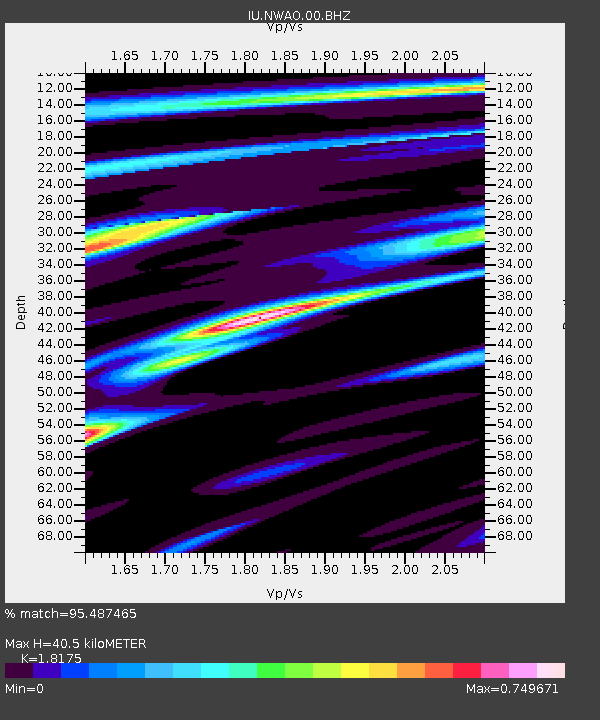
| Estimated Moho Depth: |
40.5 km |
| Estimated Crust Vp/Vs: |
1.82 |
| Assumed Crust Vp: |
6.419 km/s |
| Estimated Crust Vs: |
3.532 km/s |
| Estimated Crust Poisson's Ratio: |
0.28 |
|
| Radial Match: |
95.487465 % |
| Radial Bump: |
310 |
| Transverse Match: |
72.86953 % |
| Transverse Bump: |
400 |
| SOD ConfigId: |
822761 |
| Insert Time: |
2014-12-21 01:40:14.292 +0000 |
| GWidth: |
2.5 |
| Max Bumps: |
400 |
| Tol: |
0.001 |
|
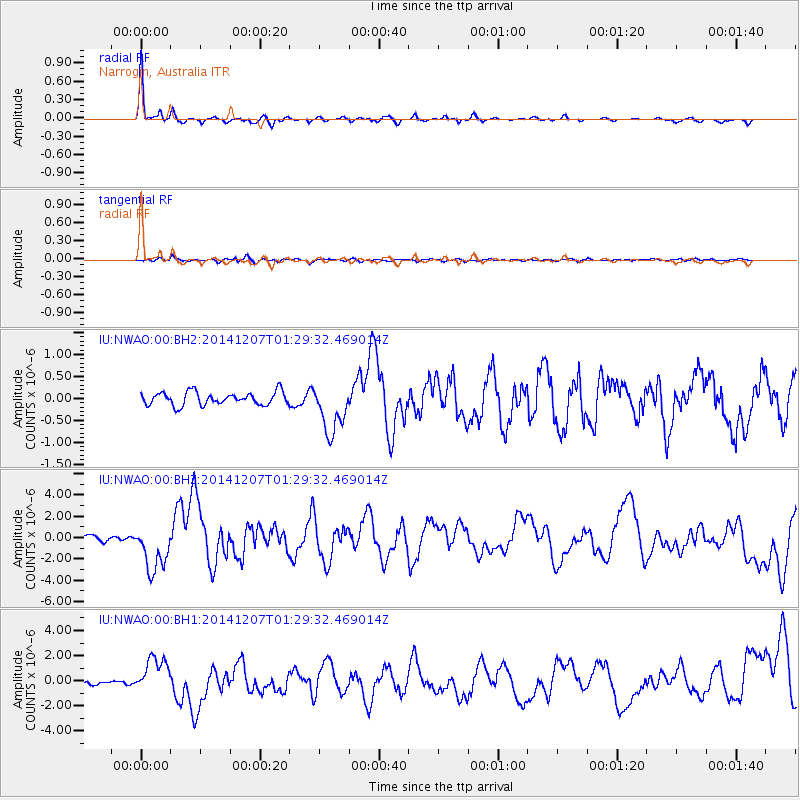
Signal To Noise
| Channel | StoN | STA | LTA |
| IU:NWAO:00:BHZ:20141207T01:29:32.469014Z | 9.967066 | 2.215886E-6 | 2.2232078E-7 |
| IU:NWAO:00:BH1:20141207T01:29:32.469014Z | 11.729076 | 1.4555387E-6 | 1.2409662E-7 |
| IU:NWAO:00:BH2:20141207T01:29:32.469014Z | 3.803913 | 5.630665E-7 | 1.4802298E-7 |
| Arrivals |
| Ps | 5.5 SECOND |
| PpPs | 17 SECOND |
| PsPs/PpSs | 22 SECOND |


