You are here: Home > Network List > WU - The Southern Ontario Seismic Network Stations List
> Station DELO Deloro Mine, Ontario, Canada > Earthquake Result Viewer
DELO Deloro Mine, Ontario, Canada - Earthquake Result Viewer
| Earthquake location: |
Near East Coast Of Honshu, Japan |
| Earthquake latitude/longitude: |
38.9/142.0 |
| Earthquake time(UTC): |
2015/05/12 (132) 21:12:58 GMT |
| Earthquake Depth: |
39 km |
| Earthquake Magnitude: |
6.8 MWP, 6.8 MI |
| Earthquake Catalog/Contributor: |
NEIC PDE/NEIC COMCAT |
|
| Network: |
WU The Southern Ontario Seismic Network |
| Station: |
DELO Deloro Mine, Ontario, Canada |
| Lat/Lon: |
44.52 N/77.62 W |
| Elevation: |
213 m |
|
| Distance: |
89.6 deg |
| Az: |
27.162 deg |
| Baz: |
330.138 deg |
| Ray Param: |
0.041728906 |
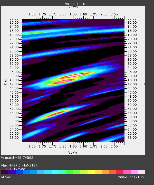
| Estimated Moho Depth: |
37.5 km |
| Estimated Crust Vp/Vs: |
1.86 |
| Assumed Crust Vp: |
6.577 km/s |
| Estimated Crust Vs: |
3.541 km/s |
| Estimated Crust Poisson's Ratio: |
0.30 |
|
| Radial Match: |
81.74582 % |
| Radial Bump: |
400 |
| Transverse Match: |
64.68 % |
| Transverse Bump: |
400 |
| SOD ConfigId: |
7422571 |
| Insert Time: |
2019-04-18 20:52:46.681 +0000 |
| GWidth: |
2.5 |
| Max Bumps: |
400 |
| Tol: |
0.001 |
|

Signal To Noise
| Channel | StoN | STA | LTA |
| WU:DELO: :HHZ:20150512T21:25:20.830005Z | 9.679376 | 1.3054092E-6 | 1.3486502E-7 |
| WU:DELO: :HHN:20150512T21:25:20.830005Z | 4.175751 | 4.8554523E-7 | 1.16277334E-7 |
| WU:DELO: :HHE:20150512T21:25:20.830005Z | 1.9142761 | 1.9347546E-7 | 1.0106978E-7 |
| Arrivals |
| Ps | 5.0 SECOND |
| PpPs | 16 SECOND |
| PsPs/PpSs | 21 SECOND |


