You are here: Home > Network List > TA - USArray Transportable Network (new EarthScope stations) Stations List
> Station A21K Barrow, AK, USA > Earthquake Result Viewer
A21K Barrow, AK, USA - Earthquake Result Viewer
| Earthquake location: |
Solomon Islands |
| Earthquake latitude/longitude: |
-6.5/154.5 |
| Earthquake time(UTC): |
2014/12/07 (341) 01:22:00 GMT |
| Earthquake Depth: |
10 km |
| Earthquake Magnitude: |
6.8 MWP, 6.7 MI, 6.8 MI |
| Earthquake Catalog/Contributor: |
NEIC PDE/NEIC COMCAT |
|
| Network: |
TA USArray Transportable Network (new EarthScope stations) |
| Station: |
A21K Barrow, AK, USA |
| Lat/Lon: |
71.32 N/156.62 W |
| Elevation: |
577 m |
|
| Distance: |
84.1 deg |
| Az: |
14.134 deg |
| Baz: |
228.857 deg |
| Ray Param: |
0.045737505 |
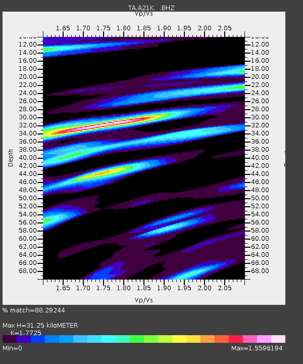
| Estimated Moho Depth: |
31.25 km |
| Estimated Crust Vp/Vs: |
1.77 |
| Assumed Crust Vp: |
6.048 km/s |
| Estimated Crust Vs: |
3.412 km/s |
| Estimated Crust Poisson's Ratio: |
0.27 |
|
| Radial Match: |
88.29244 % |
| Radial Bump: |
400 |
| Transverse Match: |
75.85812 % |
| Transverse Bump: |
400 |
| SOD ConfigId: |
822761 |
| Insert Time: |
2014-12-21 01:47:39.427 +0000 |
| GWidth: |
2.5 |
| Max Bumps: |
400 |
| Tol: |
0.001 |
|
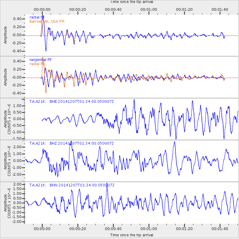
Signal To Noise
| Channel | StoN | STA | LTA |
| TA:A21K: :BHZ:20141207T01:34:00.050007Z | 7.276045 | 1.042699E-6 | 1.4330573E-7 |
| TA:A21K: :BHN:20141207T01:34:00.050007Z | 1.9178058 | 3.0482002E-7 | 1.5894207E-7 |
| TA:A21K: :BHE:20141207T01:34:00.050007Z | 1.5634315 | 3.1149997E-7 | 1.992412E-7 |
| Arrivals |
| Ps | 4.1 SECOND |
| PpPs | 14 SECOND |
| PsPs/PpSs | 18 SECOND |


