You are here: Home > Network List > TA - USArray Transportable Network (new EarthScope stations) Stations List
> Station K27K Chicken, AK, USA > Earthquake Result Viewer
K27K Chicken, AK, USA - Earthquake Result Viewer
| Earthquake location: |
Solomon Islands |
| Earthquake latitude/longitude: |
-6.5/154.5 |
| Earthquake time(UTC): |
2014/12/07 (341) 01:22:00 GMT |
| Earthquake Depth: |
10 km |
| Earthquake Magnitude: |
6.8 MWP, 6.7 MI, 6.8 MI |
| Earthquake Catalog/Contributor: |
NEIC PDE/NEIC COMCAT |
|
| Network: |
TA USArray Transportable Network (new EarthScope stations) |
| Station: |
K27K Chicken, AK, USA |
| Lat/Lon: |
64.03 N/142.08 W |
| Elevation: |
389 m |
|
| Distance: |
84.6 deg |
| Az: |
23.308 deg |
| Baz: |
243.24 deg |
| Ray Param: |
0.045356575 |
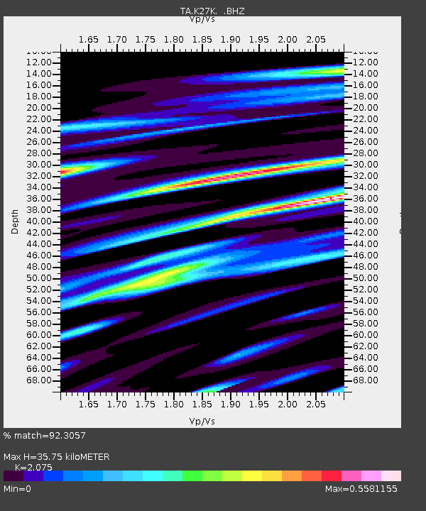
| Estimated Moho Depth: |
35.75 km |
| Estimated Crust Vp/Vs: |
2.08 |
| Assumed Crust Vp: |
6.566 km/s |
| Estimated Crust Vs: |
3.164 km/s |
| Estimated Crust Poisson's Ratio: |
0.35 |
|
| Radial Match: |
92.3057 % |
| Radial Bump: |
400 |
| Transverse Match: |
65.724815 % |
| Transverse Bump: |
400 |
| SOD ConfigId: |
822761 |
| Insert Time: |
2014-12-21 01:47:40.030 +0000 |
| GWidth: |
2.5 |
| Max Bumps: |
400 |
| Tol: |
0.001 |
|

Signal To Noise
| Channel | StoN | STA | LTA |
| TA:K27K: :BHZ:20141207T01:34:02.774983Z | 8.345788 | 1.2381929E-6 | 1.4836141E-7 |
| TA:K27K: :BHN:20141207T01:34:02.774983Z | 1.3620975 | 1.3556867E-7 | 9.9529345E-8 |
| TA:K27K: :BHE:20141207T01:34:02.774983Z | 3.479994 | 4.8260307E-7 | 1.3867927E-7 |
| Arrivals |
| Ps | 6.0 SECOND |
| PpPs | 16 SECOND |
| PsPs/PpSs | 22 SECOND |


