You are here: Home > Network List > US - United States National Seismic Network Stations List
> Station HAWA Hanford, Washington, USA > Earthquake Result Viewer
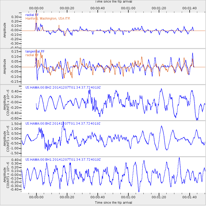
HAWA Hanford, Washington, USA - Earthquake Result Viewer
*The percent match for this event was below the threshold and hence no stack was calculated.
| Earthquake location: |
Solomon Islands |
| Earthquake latitude/longitude: |
-6.5/154.5 |
| Earthquake time(UTC): |
2014/12/07 (341) 01:22:00 GMT |
| Earthquake Depth: |
10 km |
| Earthquake Magnitude: |
6.8 MWP, 6.7 MI, 6.8 MI |
| Earthquake Catalog/Contributor: |
NEIC PDE/NEIC COMCAT |
|
| Network: |
US United States National Seismic Network |
| Station: |
HAWA Hanford, Washington, USA |
| Lat/Lon: |
46.39 N/119.53 W |
| Elevation: |
364 m |
|
| Distance: |
91.9 deg |
| Az: |
43.698 deg |
| Baz: |
262.634 deg |
| Ray Param: |
$rayparam |
*The percent match for this event was below the threshold and hence was not used in the summary stack. |
|
| Radial Match: |
61.170006 % |
| Radial Bump: |
380 |
| Transverse Match: |
48.67377 % |
| Transverse Bump: |
400 |
| SOD ConfigId: |
822761 |
| Insert Time: |
2014-12-21 01:48:33.365 +0000 |
| GWidth: |
2.5 |
| Max Bumps: |
400 |
| Tol: |
0.001 |
|
Signal To Noise
| Channel | StoN | STA | LTA |
| US:HAWA:00:BHZ:20141207T01:34:37.724019Z | 2.473602 | 6.0306695E-7 | 2.438011E-7 |
| US:HAWA:00:BH1:20141207T01:34:37.724019Z | 0.6746308 | 1.2043223E-7 | 1.7851578E-7 |
| US:HAWA:00:BH2:20141207T01:34:37.724019Z | 1.145878 | 1.8325638E-7 | 1.599266E-7 |
| Arrivals |
| Ps | |
| PpPs | |
| PsPs/PpSs | |


