You are here: Home > Network List > XD14 - Illuminating the architecture of the greater Mount St. Helens magmatic systems f Stations List
> Station MI04 "Mount St Helens, WA" > Earthquake Result Viewer
MI04 "Mount St Helens, WA" - Earthquake Result Viewer
| Earthquake location: |
Near East Coast Of Honshu, Japan |
| Earthquake latitude/longitude: |
38.9/142.0 |
| Earthquake time(UTC): |
2015/05/12 (132) 21:12:58 GMT |
| Earthquake Depth: |
39 km |
| Earthquake Magnitude: |
6.8 MWP, 6.8 MI |
| Earthquake Catalog/Contributor: |
NEIC PDE/NEIC COMCAT |
|
| Network: |
XD Illuminating the architecture of the greater Mount St. Helens magmatic systems f |
| Station: |
MI04 "Mount St Helens, WA" |
| Lat/Lon: |
46.20 N/122.41 W |
| Elevation: |
918 m |
|
| Distance: |
66.6 deg |
| Az: |
48.886 deg |
| Baz: |
302.186 deg |
| Ray Param: |
0.05745107 |
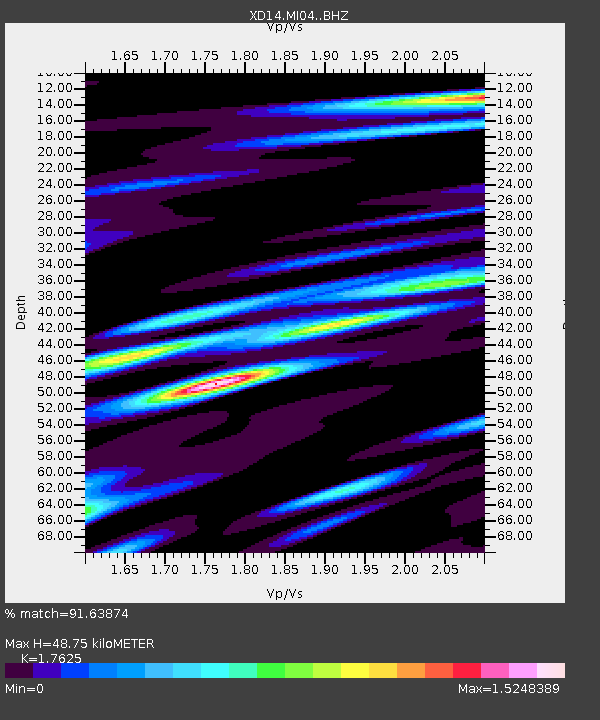
| Estimated Moho Depth: |
48.75 km |
| Estimated Crust Vp/Vs: |
1.76 |
| Assumed Crust Vp: |
6.566 km/s |
| Estimated Crust Vs: |
3.725 km/s |
| Estimated Crust Poisson's Ratio: |
0.26 |
|
| Radial Match: |
91.63874 % |
| Radial Bump: |
400 |
| Transverse Match: |
80.85827 % |
| Transverse Bump: |
400 |
| SOD ConfigId: |
7422571 |
| Insert Time: |
2019-04-18 20:53:41.081 +0000 |
| GWidth: |
2.5 |
| Max Bumps: |
400 |
| Tol: |
0.001 |
|

Signal To Noise
| Channel | StoN | STA | LTA |
| XD:MI04: :BHZ:20150512T21:23:14.004993Z | 4.5840735 | 7.0573134E-7 | 1.5395288E-7 |
| XD:MI04: :BHN:20150512T21:23:14.004993Z | 1.8142895 | 2.3079453E-7 | 1.2720932E-7 |
| XD:MI04: :BHE:20150512T21:23:14.004993Z | 1.6432188 | 3.8177765E-7 | 2.3233527E-7 |
| Arrivals |
| Ps | 5.9 SECOND |
| PpPs | 20 SECOND |
| PsPs/PpSs | 26 SECOND |


