You are here: Home > Network List > II - Global Seismograph Network (GSN - IRIS/IDA) Stations List
> Station KAPI Kappang, Sulawesi, Indonesia > Earthquake Result Viewer
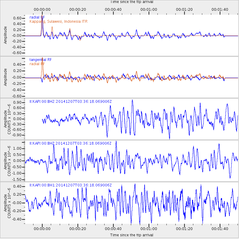
KAPI Kappang, Sulawesi, Indonesia - Earthquake Result Viewer
*The percent match for this event was below the threshold and hence no stack was calculated.
| Earthquake location: |
Solomon Islands |
| Earthquake latitude/longitude: |
-6.4/154.2 |
| Earthquake time(UTC): |
2014/12/07 (341) 03:30:02 GMT |
| Earthquake Depth: |
10 km |
| Earthquake Magnitude: |
5.7 MWP |
| Earthquake Catalog/Contributor: |
NEIC PDE/NEIC COMCAT |
|
| Network: |
II Global Seismograph Network (GSN - IRIS/IDA) |
| Station: |
KAPI Kappang, Sulawesi, Indonesia |
| Lat/Lon: |
5.01 S/119.75 E |
| Elevation: |
300 m |
|
| Distance: |
34.3 deg |
| Az: |
270.484 deg |
| Baz: |
93.997 deg |
| Ray Param: |
$rayparam |
*The percent match for this event was below the threshold and hence was not used in the summary stack. |
|
| Radial Match: |
69.61833 % |
| Radial Bump: |
400 |
| Transverse Match: |
60.258114 % |
| Transverse Bump: |
400 |
| SOD ConfigId: |
823362 |
| Insert Time: |
2014-12-21 03:51:33.123 +0000 |
| GWidth: |
2.5 |
| Max Bumps: |
400 |
| Tol: |
0.001 |
|
Signal To Noise
| Channel | StoN | STA | LTA |
| II:KAPI:00:BHZ:20141207T03:36:18.069006Z | 2.6449933 | 3.2884756E-7 | 1.2432831E-7 |
| II:KAPI:00:BH1:20141207T03:36:18.069006Z | 0.8785443 | 1.1009991E-7 | 1.2532084E-7 |
| II:KAPI:00:BH2:20141207T03:36:18.069006Z | 1.6138661 | 2.237846E-7 | 1.3866367E-7 |
| Arrivals |
| Ps | |
| PpPs | |
| PsPs/PpSs | |


