You are here: Home > Network List > TA - USArray Transportable Network (new EarthScope stations) Stations List
> Station C06D Leavenworth, WQ, USA > Earthquake Result Viewer
C06D Leavenworth, WQ, USA - Earthquake Result Viewer

| Earthquake location: |
Solomon Islands |
| Earthquake latitude/longitude: |
-6.4/154.2 |
| Earthquake time(UTC): |
2014/12/07 (341) 03:30:02 GMT |
| Earthquake Depth: |
10 km |
| Earthquake Magnitude: |
5.7 MWP |
| Earthquake Catalog/Contributor: |
NEIC PDE/NEIC COMCAT |
|
| Network: |
TA USArray Transportable Network (new EarthScope stations) |
| Station: |
C06D Leavenworth, WQ, USA |
| Lat/Lon: |
47.92 N/120.89 W |
| Elevation: |
544 m |
|
| Distance: |
91.3 deg |
| Az: |
42.074 deg |
| Baz: |
261.938 deg |
| Ray Param: |
0.04161319 |
| Estimated Moho Depth: |
25.0 km |
| Estimated Crust Vp/Vs: |
1.63 |
| Assumed Crust Vp: |
6.597 km/s |
| Estimated Crust Vs: |
4.041 km/s |
| Estimated Crust Poisson's Ratio: |
0.20 |
|
| Radial Match: |
82.13307 % |
| Radial Bump: |
400 |
| Transverse Match: |
57.53222 % |
| Transverse Bump: |
400 |
| SOD ConfigId: |
823362 |
| Insert Time: |
2014-12-21 03:56:18.409 +0000 |
| GWidth: |
2.5 |
| Max Bumps: |
400 |
| Tol: |
0.001 |
|
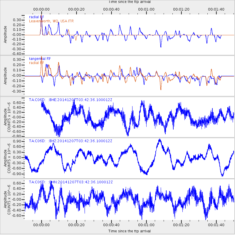
Signal To Noise
| Channel | StoN | STA | LTA |
| TA:C06D: :BHZ:20141207T03:42:36.100012Z | 0.65521824 | 3.1221728E-7 | 4.7650886E-7 |
| TA:C06D: :BHN:20141207T03:42:36.100012Z | 1.7328267 | 3.6243352E-7 | 2.0915739E-7 |
| TA:C06D: :BHE:20141207T03:42:36.100012Z | 1.0441567 | 3.6656564E-7 | 3.5106382E-7 |
| Arrivals |
| Ps | 2.5 SECOND |
| PpPs | 9.7 SECOND |
| PsPs/PpSs | 12 SECOND |


