You are here: Home > Network List > AK - Alaska Regional Network Stations List
> Station MDM Murphy Dome > Earthquake Result Viewer
MDM Murphy Dome - Earthquake Result Viewer
*The percent match for this event was below the threshold and hence no stack was calculated.
| Earthquake location: |
Near Coast Of Guatemala |
| Earthquake latitude/longitude: |
13.8/-91.4 |
| Earthquake time(UTC): |
2014/12/07 (341) 12:11:33 GMT |
| Earthquake Depth: |
43 km |
| Earthquake Magnitude: |
5.6 MB |
| Earthquake Catalog/Contributor: |
NEIC PDE/NEIC COMCAT |
|
| Network: |
AK Alaska Regional Network |
| Station: |
MDM Murphy Dome |
| Lat/Lon: |
64.96 N/148.23 W |
| Elevation: |
634 m |
|
| Distance: |
63.9 deg |
| Az: |
336.629 deg |
| Baz: |
115.09 deg |
| Ray Param: |
$rayparam |
*The percent match for this event was below the threshold and hence was not used in the summary stack. |
|
| Radial Match: |
49.462036 % |
| Radial Bump: |
400 |
| Transverse Match: |
59.300365 % |
| Transverse Bump: |
361 |
| SOD ConfigId: |
823428 |
| Insert Time: |
2014-12-21 12:24:20.740 +0000 |
| GWidth: |
2.5 |
| Max Bumps: |
400 |
| Tol: |
0.001 |
|
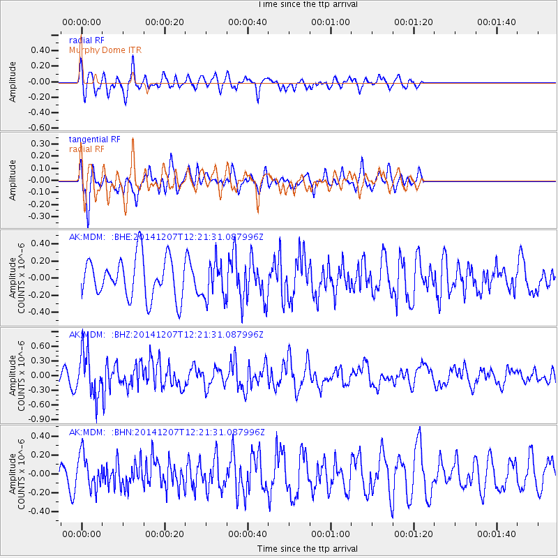
Signal To Noise
| Channel | StoN | STA | LTA |
| AK:MDM: :BHZ:20141207T12:21:31.087996Z | 2.3920238 | 4.5697917E-7 | 1.9104291E-7 |
| AK:MDM: :BHN:20141207T12:21:31.087996Z | 1.3754292 | 1.8668318E-7 | 1.3572722E-7 |
| AK:MDM: :BHE:20141207T12:21:31.087996Z | 0.90286505 | 2.1108137E-7 | 2.337906E-7 |
| Arrivals |
| Ps | |
| PpPs | |
| PsPs/PpSs | |


