You are here: Home > Network List > CI - Caltech Regional Seismic Network Stations List
> Station MPM Manuel Prospect Mine, California, USA > Earthquake Result Viewer
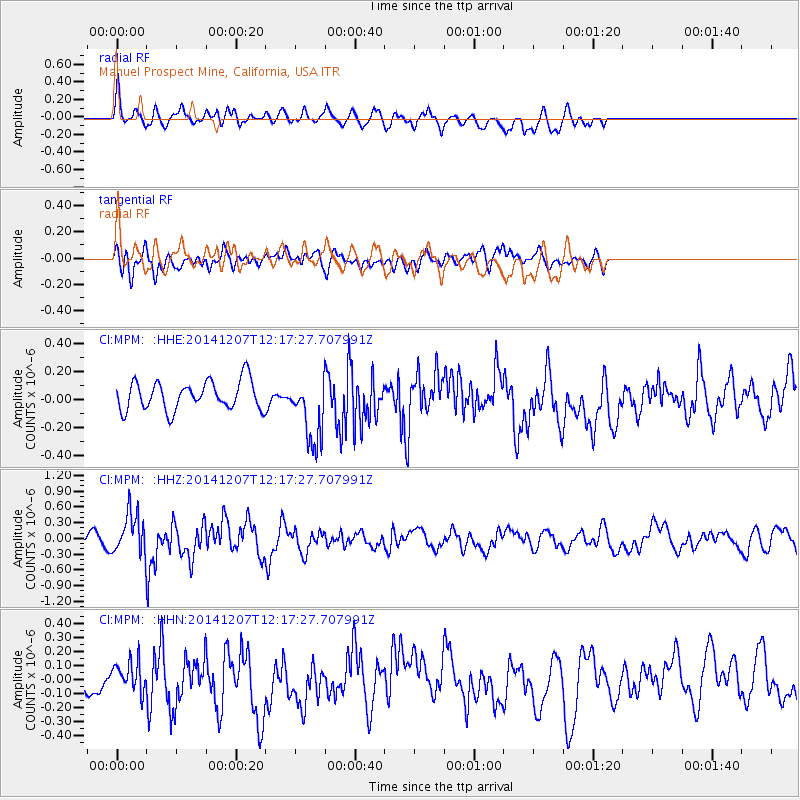
MPM Manuel Prospect Mine, California, USA - Earthquake Result Viewer
*The percent match for this event was below the threshold and hence no stack was calculated.
| Earthquake location: |
Near Coast Of Guatemala |
| Earthquake latitude/longitude: |
13.8/-91.4 |
| Earthquake time(UTC): |
2014/12/07 (341) 12:11:33 GMT |
| Earthquake Depth: |
43 km |
| Earthquake Magnitude: |
5.6 MB |
| Earthquake Catalog/Contributor: |
NEIC PDE/NEIC COMCAT |
|
| Network: |
CI Caltech Regional Seismic Network |
| Station: |
MPM Manuel Prospect Mine, California, USA |
| Lat/Lon: |
36.06 N/117.49 W |
| Elevation: |
185 m |
|
| Distance: |
32.3 deg |
| Az: |
318.139 deg |
| Baz: |
126.848 deg |
| Ray Param: |
$rayparam |
*The percent match for this event was below the threshold and hence was not used in the summary stack. |
|
| Radial Match: |
49.926575 % |
| Radial Bump: |
400 |
| Transverse Match: |
60.032997 % |
| Transverse Bump: |
400 |
| SOD ConfigId: |
823428 |
| Insert Time: |
2014-12-21 12:30:07.567 +0000 |
| GWidth: |
2.5 |
| Max Bumps: |
400 |
| Tol: |
0.001 |
|
Signal To Noise
| Channel | StoN | STA | LTA |
| CI:MPM: :HHZ:20141207T12:17:27.707991Z | 3.0897841 | 3.8631907E-7 | 1.250311E-7 |
| CI:MPM: :HHN:20141207T12:17:27.707991Z | 0.9612893 | 1.0425507E-7 | 1.0845338E-7 |
| CI:MPM: :HHE:20141207T12:17:27.707991Z | 2.3339832 | 2.393316E-7 | 1.02542124E-7 |
| Arrivals |
| Ps | |
| PpPs | |
| PsPs/PpSs | |


