You are here: Home > Network List > AK - Alaska Regional Network Stations List
> Station KLU Klutina Pass, Alaska, USA > Earthquake Result Viewer
KLU Klutina Pass, Alaska, USA - Earthquake Result Viewer
| Earthquake location: |
Nepal-India Border Region |
| Earthquake latitude/longitude: |
27.8/84.7 |
| Earthquake time(UTC): |
2015/05/12 (132) 21:25:11 GMT |
| Earthquake Depth: |
2.5 km |
| Earthquake Magnitude: |
5.2 mb, 5.1 mb |
| Earthquake Catalog/Contributor: |
ISC/ISC |
|
| Network: |
AK Alaska Regional Network |
| Station: |
KLU Klutina Pass, Alaska, USA |
| Lat/Lon: |
61.49 N/145.92 W |
| Elevation: |
1021 m |
|
| Distance: |
82.1 deg |
| Az: |
21.989 deg |
| Baz: |
316.242 deg |
| Ray Param: |
0.047114942 |
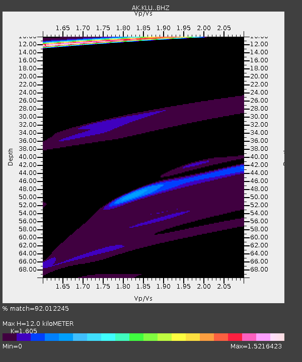
| Estimated Moho Depth: |
12.0 km |
| Estimated Crust Vp/Vs: |
1.61 |
| Assumed Crust Vp: |
6.566 km/s |
| Estimated Crust Vs: |
4.091 km/s |
| Estimated Crust Poisson's Ratio: |
0.18 |
|
| Radial Match: |
92.012245 % |
| Radial Bump: |
385 |
| Transverse Match: |
89.64708 % |
| Transverse Bump: |
271 |
| SOD ConfigId: |
7422571 |
| Insert Time: |
2019-04-18 20:56:10.942 +0000 |
| GWidth: |
2.5 |
| Max Bumps: |
400 |
| Tol: |
0.001 |
|

Signal To Noise
| Channel | StoN | STA | LTA |
| AK:KLU: :BHZ:20150512T21:37:01.827983Z | 0.7687131 | 3.4772013E-6 | 4.5234056E-6 |
| AK:KLU: :BHN:20150512T21:37:01.827983Z | 0.8909713 | 2.820601E-6 | 3.1657594E-6 |
| AK:KLU: :BHE:20150512T21:37:01.827983Z | 1.805325 | 8.012624E-6 | 4.4383273E-6 |
| Arrivals |
| Ps | 1.1 SECOND |
| PpPs | 4.6 SECOND |
| PsPs/PpSs | 5.8 SECOND |


