You are here: Home > Network List > G - GEOSCOPE Stations List
> Station MPG Montagne des Peres, French Guyana > Earthquake Result Viewer
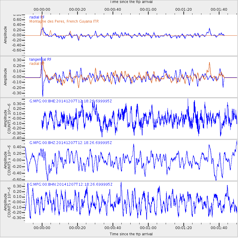
MPG Montagne des Peres, French Guyana - Earthquake Result Viewer
*The percent match for this event was below the threshold and hence no stack was calculated.
| Earthquake location: |
Near Coast Of Guatemala |
| Earthquake latitude/longitude: |
13.8/-91.4 |
| Earthquake time(UTC): |
2014/12/07 (341) 12:11:33 GMT |
| Earthquake Depth: |
43 km |
| Earthquake Magnitude: |
5.6 MB |
| Earthquake Catalog/Contributor: |
NEIC PDE/NEIC COMCAT |
|
| Network: |
G GEOSCOPE |
| Station: |
MPG Montagne des Peres, French Guyana |
| Lat/Lon: |
5.11 N/52.64 W |
| Elevation: |
147 m |
|
| Distance: |
39.2 deg |
| Az: |
98.886 deg |
| Baz: |
285.463 deg |
| Ray Param: |
$rayparam |
*The percent match for this event was below the threshold and hence was not used in the summary stack. |
|
| Radial Match: |
65.44359 % |
| Radial Bump: |
400 |
| Transverse Match: |
60.429607 % |
| Transverse Bump: |
400 |
| SOD ConfigId: |
823428 |
| Insert Time: |
2014-12-21 12:34:05.095 +0000 |
| GWidth: |
2.5 |
| Max Bumps: |
400 |
| Tol: |
0.001 |
|
Signal To Noise
| Channel | StoN | STA | LTA |
| G:MPG:00:BHZ:20141207T12:18:26.699995Z | 2.4090743 | 3.04701E-7 | 1.2648053E-7 |
| G:MPG:00:BHN:20141207T12:18:26.699995Z | 0.74411076 | 1.1480256E-7 | 1.5428154E-7 |
| G:MPG:00:BHE:20141207T12:18:26.699995Z | 1.68065 | 1.9489703E-7 | 1.1596527E-7 |
| Arrivals |
| Ps | |
| PpPs | |
| PsPs/PpSs | |


