You are here: Home > Network List > IU - Global Seismograph Network (GSN - IRIS/USGS) Stations List
> Station TIXI Tiksi, Russia > Earthquake Result Viewer
TIXI Tiksi, Russia - Earthquake Result Viewer
| Earthquake location: |
Vanuatu Islands |
| Earthquake latitude/longitude: |
-17.6/167.9 |
| Earthquake time(UTC): |
2002/01/02 (002) 17:22:48 GMT |
| Earthquake Depth: |
21 km |
| Earthquake Magnitude: |
6.3 MB, 7.5 MS, 7.3 MW, 7.1 MW |
| Earthquake Catalog/Contributor: |
WHDF/NEIC |
|
| Network: |
IU Global Seismograph Network (GSN - IRIS/USGS) |
| Station: |
TIXI Tiksi, Russia |
| Lat/Lon: |
71.65 N/128.87 E |
| Elevation: |
50 m |
|
| Distance: |
92.9 deg |
| Az: |
348.49 deg |
| Baz: |
143.069 deg |
| Ray Param: |
0.041366193 |
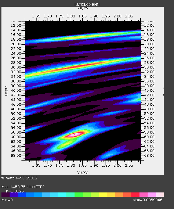
| Estimated Moho Depth: |
58.75 km |
| Estimated Crust Vp/Vs: |
1.81 |
| Assumed Crust Vp: |
6.552 km/s |
| Estimated Crust Vs: |
3.615 km/s |
| Estimated Crust Poisson's Ratio: |
0.28 |
|
| Radial Match: |
96.55812 % |
| Radial Bump: |
400 |
| Transverse Match: |
90.53833 % |
| Transverse Bump: |
400 |
| SOD ConfigId: |
20082 |
| Insert Time: |
2010-03-02 14:39:36.853 +0000 |
| GWidth: |
2.5 |
| Max Bumps: |
400 |
| Tol: |
0.001 |
|
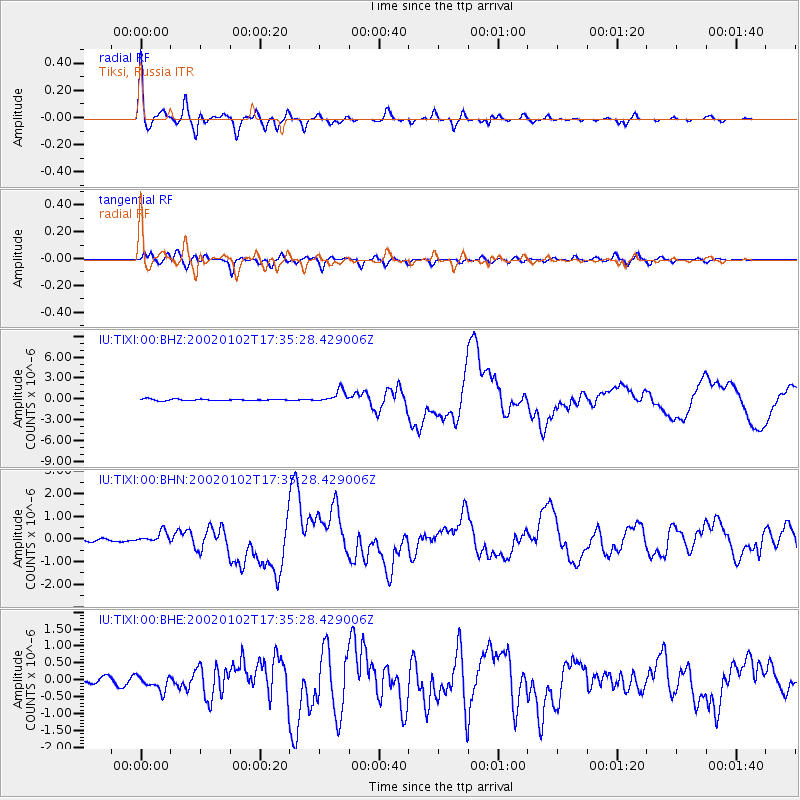
Signal To Noise
| Channel | StoN | STA | LTA |
| IU:TIXI:00:BHN:20020102T17:35:28.429006Z | 3.496212 | 2.3808192E-7 | 6.809711E-8 |
| IU:TIXI:00:BHE:20020102T17:35:28.429006Z | 2.0654335 | 2.447858E-7 | 1.1851546E-7 |
| IU:TIXI:00:BHZ:20020102T17:35:28.429006Z | 8.609524 | 8.978666E-7 | 1.0428761E-7 |
| Arrivals |
| Ps | 7.4 SECOND |
| PpPs | 25 SECOND |
| PsPs/PpSs | 32 SECOND |


