You are here: Home > Network List > TA - USArray Transportable Network (new EarthScope stations) Stations List
> Station J05D Fort Rock, OR, USA > Earthquake Result Viewer
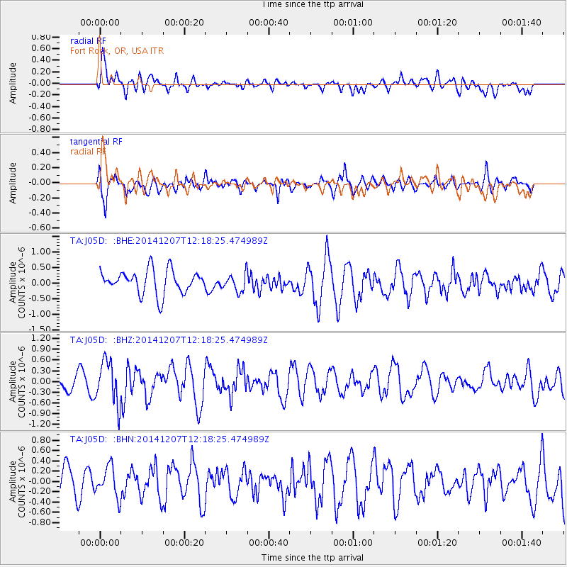
J05D Fort Rock, OR, USA - Earthquake Result Viewer
*The percent match for this event was below the threshold and hence no stack was calculated.
| Earthquake location: |
Near Coast Of Guatemala |
| Earthquake latitude/longitude: |
13.8/-91.4 |
| Earthquake time(UTC): |
2014/12/07 (341) 12:11:33 GMT |
| Earthquake Depth: |
43 km |
| Earthquake Magnitude: |
5.6 MB |
| Earthquake Catalog/Contributor: |
NEIC PDE/NEIC COMCAT |
|
| Network: |
TA USArray Transportable Network (new EarthScope stations) |
| Station: |
J05D Fort Rock, OR, USA |
| Lat/Lon: |
43.28 N/121.23 W |
| Elevation: |
1541 m |
|
| Distance: |
39.0 deg |
| Az: |
324.769 deg |
| Baz: |
129.86 deg |
| Ray Param: |
$rayparam |
*The percent match for this event was below the threshold and hence was not used in the summary stack. |
|
| Radial Match: |
52.97397 % |
| Radial Bump: |
400 |
| Transverse Match: |
57.963844 % |
| Transverse Bump: |
400 |
| SOD ConfigId: |
823428 |
| Insert Time: |
2014-12-21 12:45:45.137 +0000 |
| GWidth: |
2.5 |
| Max Bumps: |
400 |
| Tol: |
0.001 |
|
Signal To Noise
| Channel | StoN | STA | LTA |
| TA:J05D: :BHZ:20141207T12:18:25.474989Z | 1.9853021 | 6.0612984E-7 | 3.0530862E-7 |
| TA:J05D: :BHN:20141207T12:18:25.474989Z | 0.7591193 | 3.0269064E-7 | 3.9873922E-7 |
| TA:J05D: :BHE:20141207T12:18:25.474989Z | 0.7809236 | 2.948156E-7 | 3.7752173E-7 |
| Arrivals |
| Ps | |
| PpPs | |
| PsPs/PpSs | |


