You are here: Home > Network List > TA - USArray Transportable Network (new EarthScope stations) Stations List
> Station MDND Maddock, ND, USA > Earthquake Result Viewer
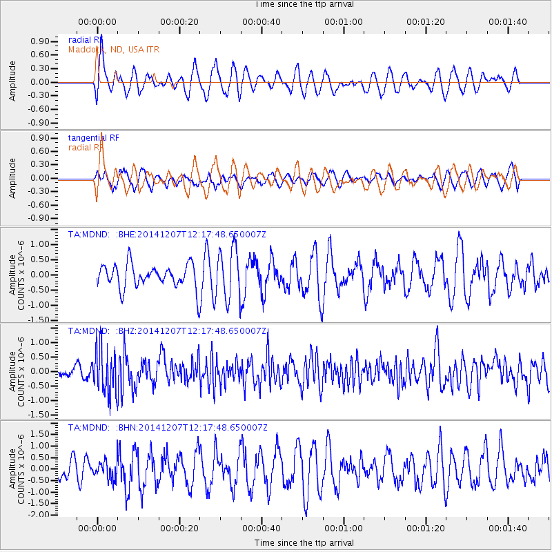
MDND Maddock, ND, USA - Earthquake Result Viewer
*The percent match for this event was below the threshold and hence no stack was calculated.
| Earthquake location: |
Near Coast Of Guatemala |
| Earthquake latitude/longitude: |
13.8/-91.4 |
| Earthquake time(UTC): |
2014/12/07 (341) 12:11:33 GMT |
| Earthquake Depth: |
43 km |
| Earthquake Magnitude: |
5.6 MB |
| Earthquake Catalog/Contributor: |
NEIC PDE/NEIC COMCAT |
|
| Network: |
TA USArray Transportable Network (new EarthScope stations) |
| Station: |
MDND Maddock, ND, USA |
| Lat/Lon: |
47.85 N/99.60 W |
| Elevation: |
479 m |
|
| Distance: |
34.7 deg |
| Az: |
350.294 deg |
| Baz: |
165.924 deg |
| Ray Param: |
$rayparam |
*The percent match for this event was below the threshold and hence was not used in the summary stack. |
|
| Radial Match: |
59.523396 % |
| Radial Bump: |
400 |
| Transverse Match: |
61.61007 % |
| Transverse Bump: |
380 |
| SOD ConfigId: |
823428 |
| Insert Time: |
2014-12-21 12:46:43.740 +0000 |
| GWidth: |
2.5 |
| Max Bumps: |
400 |
| Tol: |
0.001 |
|
Signal To Noise
| Channel | StoN | STA | LTA |
| TA:MDND: :BHZ:20141207T12:17:48.650007Z | 3.9398675 | 7.76267E-7 | 1.970287E-7 |
| TA:MDND: :BHN:20141207T12:17:48.650007Z | 0.659779 | 4.0197486E-7 | 6.0925686E-7 |
| TA:MDND: :BHE:20141207T12:17:48.650007Z | 2.1670172 | 8.384892E-7 | 3.869324E-7 |
| Arrivals |
| Ps | |
| PpPs | |
| PsPs/PpSs | |


