You are here: Home > Network List > TA - USArray Transportable Network (new EarthScope stations) Stations List
> Station A21K Barrow, AK, USA > Earthquake Result Viewer
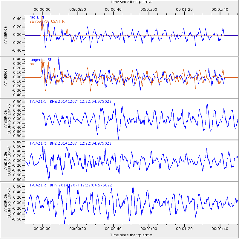
A21K Barrow, AK, USA - Earthquake Result Viewer
*The percent match for this event was below the threshold and hence no stack was calculated.
| Earthquake location: |
Near Coast Of Guatemala |
| Earthquake latitude/longitude: |
13.8/-91.4 |
| Earthquake time(UTC): |
2014/12/07 (341) 12:11:33 GMT |
| Earthquake Depth: |
43 km |
| Earthquake Magnitude: |
5.6 MB |
| Earthquake Catalog/Contributor: |
NEIC PDE/NEIC COMCAT |
|
| Network: |
TA USArray Transportable Network (new EarthScope stations) |
| Station: |
A21K Barrow, AK, USA |
| Lat/Lon: |
71.32 N/156.62 W |
| Elevation: |
577 m |
|
| Distance: |
69.2 deg |
| Az: |
341.769 deg |
| Baz: |
109.348 deg |
| Ray Param: |
$rayparam |
*The percent match for this event was below the threshold and hence was not used in the summary stack. |
|
| Radial Match: |
58.598255 % |
| Radial Bump: |
393 |
| Transverse Match: |
46.256115 % |
| Transverse Bump: |
400 |
| SOD ConfigId: |
823428 |
| Insert Time: |
2014-12-21 12:47:14.079 +0000 |
| GWidth: |
2.5 |
| Max Bumps: |
400 |
| Tol: |
0.001 |
|
Signal To Noise
| Channel | StoN | STA | LTA |
| TA:A21K: :BHZ:20141207T12:22:04.97502Z | 3.4815965 | 4.01465E-7 | 1.15310606E-7 |
| TA:A21K: :BHN:20141207T12:22:04.97502Z | 0.78147066 | 1.312068E-7 | 1.6789728E-7 |
| TA:A21K: :BHE:20141207T12:22:04.97502Z | 2.3205225 | 3.840421E-7 | 1.6549812E-7 |
| Arrivals |
| Ps | |
| PpPs | |
| PsPs/PpSs | |


