You are here: Home > Network List > TA - USArray Transportable Network (new EarthScope stations) Stations List
> Station I23K Minto, Yukon-Koyukuk, AK, USA > Earthquake Result Viewer
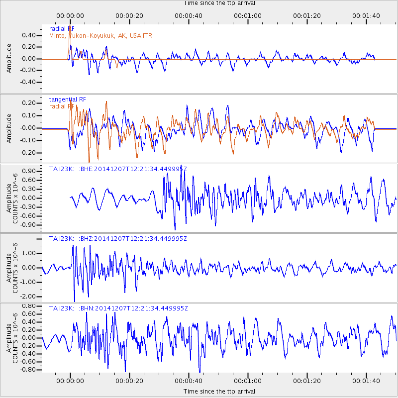
I23K Minto, Yukon-Koyukuk, AK, USA - Earthquake Result Viewer
*The percent match for this event was below the threshold and hence no stack was calculated.
| Earthquake location: |
Near Coast Of Guatemala |
| Earthquake latitude/longitude: |
13.8/-91.4 |
| Earthquake time(UTC): |
2014/12/07 (341) 12:11:33 GMT |
| Earthquake Depth: |
43 km |
| Earthquake Magnitude: |
5.6 MB |
| Earthquake Catalog/Contributor: |
NEIC PDE/NEIC COMCAT |
|
| Network: |
TA USArray Transportable Network (new EarthScope stations) |
| Station: |
I23K Minto, Yukon-Koyukuk, AK, USA |
| Lat/Lon: |
65.15 N/149.36 W |
| Elevation: |
149 m |
|
| Distance: |
64.4 deg |
| Az: |
336.599 deg |
| Baz: |
114.053 deg |
| Ray Param: |
$rayparam |
*The percent match for this event was below the threshold and hence was not used in the summary stack. |
|
| Radial Match: |
62.08107 % |
| Radial Bump: |
400 |
| Transverse Match: |
49.06945 % |
| Transverse Bump: |
377 |
| SOD ConfigId: |
823428 |
| Insert Time: |
2014-12-21 12:47:27.431 +0000 |
| GWidth: |
2.5 |
| Max Bumps: |
400 |
| Tol: |
0.001 |
|
Signal To Noise
| Channel | StoN | STA | LTA |
| TA:I23K: :BHZ:20141207T12:21:34.449995Z | 3.7216477 | 9.2063954E-7 | 2.4737417E-7 |
| TA:I23K: :BHN:20141207T12:21:34.449995Z | 0.9100977 | 2.4311214E-7 | 2.6712752E-7 |
| TA:I23K: :BHE:20141207T12:21:34.449995Z | 2.7234893 | 4.4442476E-7 | 1.6318212E-7 |
| Arrivals |
| Ps | |
| PpPs | |
| PsPs/PpSs | |


