You are here: Home > Network List > UW - Pacific Northwest Regional Seismic Network Stations List
> Station UMAT Pilot Rock, OR, USA > Earthquake Result Viewer
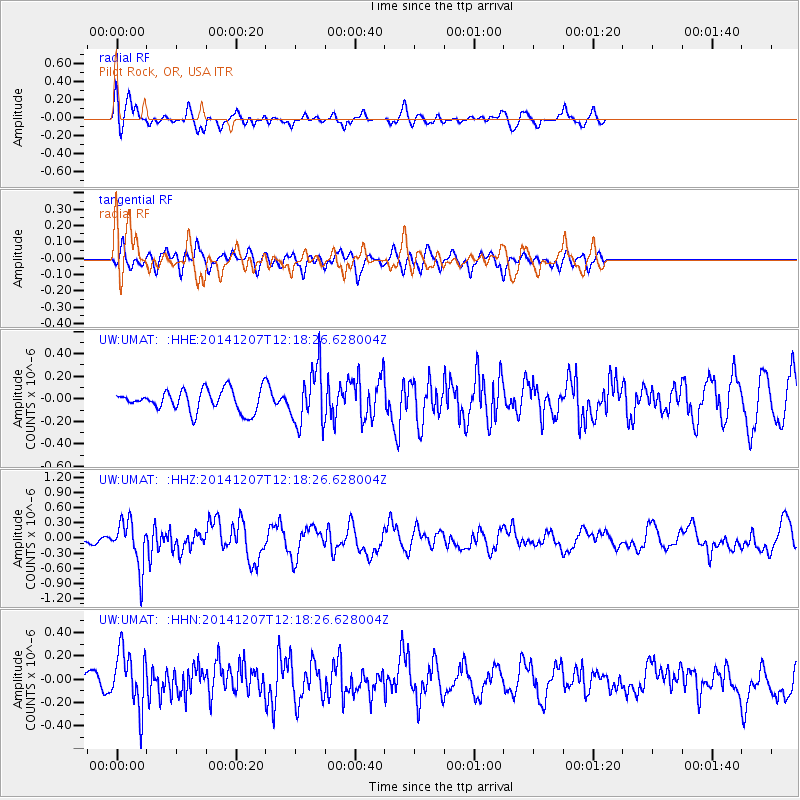
UMAT Pilot Rock, OR, USA - Earthquake Result Viewer
*The percent match for this event was below the threshold and hence no stack was calculated.
| Earthquake location: |
Near Coast Of Guatemala |
| Earthquake latitude/longitude: |
13.8/-91.4 |
| Earthquake time(UTC): |
2014/12/07 (341) 12:11:33 GMT |
| Earthquake Depth: |
43 km |
| Earthquake Magnitude: |
5.6 MB |
| Earthquake Catalog/Contributor: |
NEIC PDE/NEIC COMCAT |
|
| Network: |
UW Pacific Northwest Regional Seismic Network |
| Station: |
UMAT Pilot Rock, OR, USA |
| Lat/Lon: |
45.29 N/118.96 W |
| Elevation: |
1318 m |
|
| Distance: |
39.1 deg |
| Az: |
328.866 deg |
| Baz: |
134.626 deg |
| Ray Param: |
$rayparam |
*The percent match for this event was below the threshold and hence was not used in the summary stack. |
|
| Radial Match: |
67.03895 % |
| Radial Bump: |
400 |
| Transverse Match: |
56.81808 % |
| Transverse Bump: |
400 |
| SOD ConfigId: |
823428 |
| Insert Time: |
2014-12-21 12:51:07.063 +0000 |
| GWidth: |
2.5 |
| Max Bumps: |
400 |
| Tol: |
0.001 |
|
Signal To Noise
| Channel | StoN | STA | LTA |
| UW:UMAT: :HHZ:20141207T12:18:26.628004Z | 2.8212953 | 4.4999484E-7 | 1.5949938E-7 |
| UW:UMAT: :HHN:20141207T12:18:26.628004Z | 2.3855917 | 2.4081834E-7 | 1.0094701E-7 |
| UW:UMAT: :HHE:20141207T12:18:26.628004Z | 2.599424 | 2.471915E-7 | 9.5094734E-8 |
| Arrivals |
| Ps | |
| PpPs | |
| PsPs/PpSs | |


