You are here: Home > Network List > TA - USArray Transportable Network (new EarthScope stations) Stations List
> Station O03E Paynes Creek, CA, USA > Earthquake Result Viewer
O03E Paynes Creek, CA, USA - Earthquake Result Viewer
| Earthquake location: |
Vanuatu Islands Region |
| Earthquake latitude/longitude: |
-20.6/174.7 |
| Earthquake time(UTC): |
2015/05/12 (132) 22:31:45 GMT |
| Earthquake Depth: |
0.0 km |
| Earthquake Magnitude: |
3.8 mb, 5.9 ML, 4.0 mbtmp, 3.8 mb1mx, 4.1 mb1 |
| Earthquake Catalog/Contributor: |
ISC/ISC |
|
| Network: |
TA USArray Transportable Network (new EarthScope stations) |
| Station: |
O03E Paynes Creek, CA, USA |
| Lat/Lon: |
40.29 N/121.80 W |
| Elevation: |
967 m |
|
| Distance: |
84.6 deg |
| Az: |
43.451 deg |
| Baz: |
237.373 deg |
| Ray Param: |
0.045366224 |
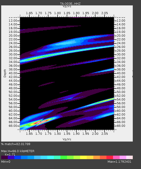
| Estimated Moho Depth: |
66.0 km |
| Estimated Crust Vp/Vs: |
1.71 |
| Assumed Crust Vp: |
6.566 km/s |
| Estimated Crust Vs: |
3.84 km/s |
| Estimated Crust Poisson's Ratio: |
0.24 |
|
| Radial Match: |
82.01789 % |
| Radial Bump: |
358 |
| Transverse Match: |
76.189674 % |
| Transverse Bump: |
400 |
| SOD ConfigId: |
7422571 |
| Insert Time: |
2019-04-18 21:01:59.211 +0000 |
| GWidth: |
2.5 |
| Max Bumps: |
400 |
| Tol: |
0.001 |
|
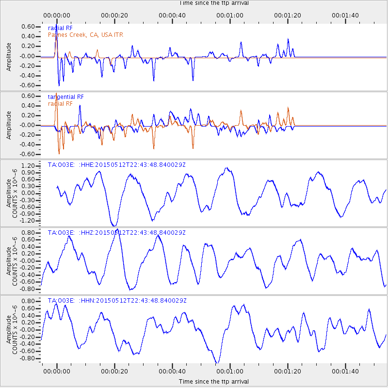
Signal To Noise
| Channel | StoN | STA | LTA |
| TA:O03E: :HHZ:20150512T22:43:48.840029Z | 0.68277013 | 4.292315E-7 | 6.286618E-7 |
| TA:O03E: :HHN:20150512T22:43:48.840029Z | 1.7181288 | 7.479621E-7 | 4.353353E-7 |
| TA:O03E: :HHE:20150512T22:43:48.840029Z | 1.1938274 | 7.5188524E-7 | 6.298107E-7 |
| Arrivals |
| Ps | 7.3 SECOND |
| PpPs | 27 SECOND |
| PsPs/PpSs | 34 SECOND |


