You are here: Home > Network List > CI - Caltech Regional Seismic Network Stations List
> Station MPM Manuel Prospect Mine, California, USA > Earthquake Result Viewer
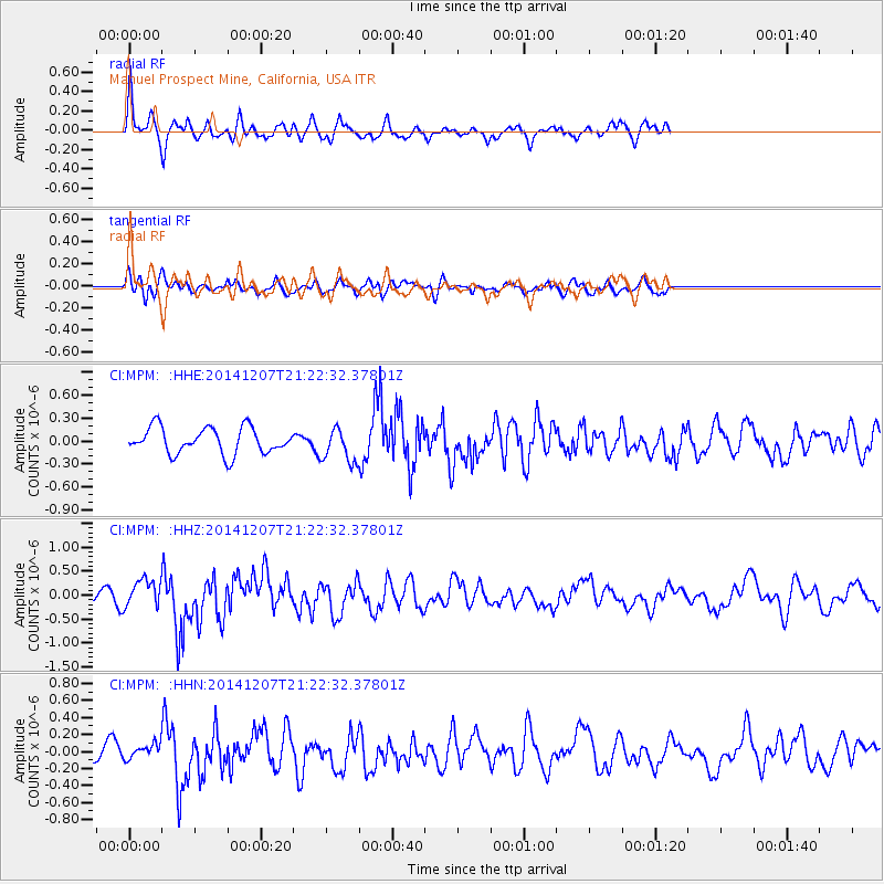
MPM Manuel Prospect Mine, California, USA - Earthquake Result Viewer
*The percent match for this event was below the threshold and hence no stack was calculated.
| Earthquake location: |
Near Coast Of Guatemala |
| Earthquake latitude/longitude: |
13.7/-91.4 |
| Earthquake time(UTC): |
2014/12/07 (341) 21:16:37 GMT |
| Earthquake Depth: |
33 km |
| Earthquake Magnitude: |
5.8 MWB |
| Earthquake Catalog/Contributor: |
NEIC PDE/NEIC COMCAT |
|
| Network: |
CI Caltech Regional Seismic Network |
| Station: |
MPM Manuel Prospect Mine, California, USA |
| Lat/Lon: |
36.06 N/117.49 W |
| Elevation: |
185 m |
|
| Distance: |
32.3 deg |
| Az: |
318.182 deg |
| Baz: |
126.904 deg |
| Ray Param: |
$rayparam |
*The percent match for this event was below the threshold and hence was not used in the summary stack. |
|
| Radial Match: |
74.59218 % |
| Radial Bump: |
400 |
| Transverse Match: |
58.661316 % |
| Transverse Bump: |
400 |
| SOD ConfigId: |
823789 |
| Insert Time: |
2014-12-21 21:34:38.555 +0000 |
| GWidth: |
2.5 |
| Max Bumps: |
400 |
| Tol: |
0.001 |
|
Signal To Noise
| Channel | StoN | STA | LTA |
| CI:MPM: :HHZ:20141207T21:22:32.37801Z | 2.151209 | 2.8620272E-7 | 1.3304273E-7 |
| CI:MPM: :HHN:20141207T21:22:32.37801Z | 0.9855621 | 8.176662E-8 | 8.2964455E-8 |
| CI:MPM: :HHE:20141207T21:22:32.37801Z | 1.3181413 | 2.2407978E-7 | 1.6999678E-7 |
| Arrivals |
| Ps | |
| PpPs | |
| PsPs/PpSs | |


