You are here: Home > Network List > G - GEOSCOPE Stations List
> Station MPG Montagne des Peres, French Guyana > Earthquake Result Viewer
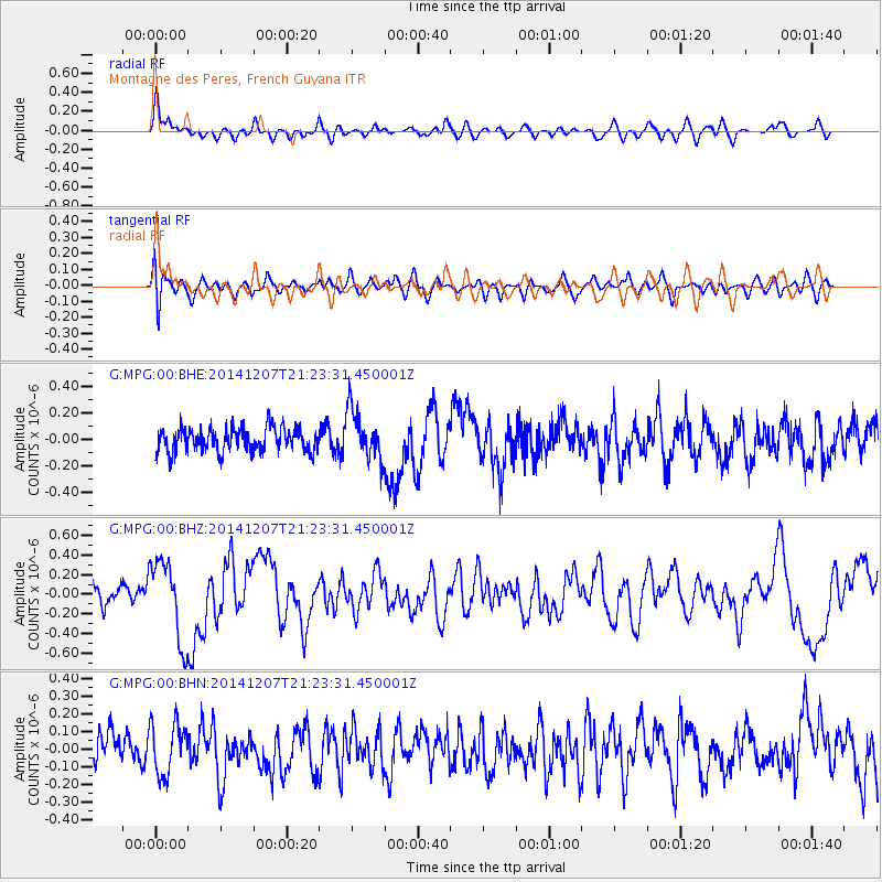
MPG Montagne des Peres, French Guyana - Earthquake Result Viewer
*The percent match for this event was below the threshold and hence no stack was calculated.
| Earthquake location: |
Near Coast Of Guatemala |
| Earthquake latitude/longitude: |
13.7/-91.4 |
| Earthquake time(UTC): |
2014/12/07 (341) 21:16:37 GMT |
| Earthquake Depth: |
33 km |
| Earthquake Magnitude: |
5.8 MWB |
| Earthquake Catalog/Contributor: |
NEIC PDE/NEIC COMCAT |
|
| Network: |
G GEOSCOPE |
| Station: |
MPG Montagne des Peres, French Guyana |
| Lat/Lon: |
5.11 N/52.64 W |
| Elevation: |
147 m |
|
| Distance: |
39.2 deg |
| Az: |
98.849 deg |
| Baz: |
285.421 deg |
| Ray Param: |
$rayparam |
*The percent match for this event was below the threshold and hence was not used in the summary stack. |
|
| Radial Match: |
75.27838 % |
| Radial Bump: |
400 |
| Transverse Match: |
47.50586 % |
| Transverse Bump: |
400 |
| SOD ConfigId: |
823789 |
| Insert Time: |
2014-12-21 21:37:34.743 +0000 |
| GWidth: |
2.5 |
| Max Bumps: |
400 |
| Tol: |
0.001 |
|
Signal To Noise
| Channel | StoN | STA | LTA |
| G:MPG:00:BHZ:20141207T21:23:31.450001Z | 3.1204007 | 4.0883944E-7 | 1.3102147E-7 |
| G:MPG:00:BHN:20141207T21:23:31.450001Z | 1.3758637 | 1.4658329E-7 | 1.06539105E-7 |
| G:MPG:00:BHE:20141207T21:23:31.450001Z | 2.1125078 | 1.8764985E-7 | 8.8827996E-8 |
| Arrivals |
| Ps | |
| PpPs | |
| PsPs/PpSs | |


