You are here: Home > Network List > IU - Global Seismograph Network (GSN - IRIS/USGS) Stations List
> Station SAML Samuel, Brazil > Earthquake Result Viewer
SAML Samuel, Brazil - Earthquake Result Viewer
| Earthquake location: |
Near Coast Of Guatemala |
| Earthquake latitude/longitude: |
13.7/-91.4 |
| Earthquake time(UTC): |
2014/12/07 (341) 21:16:37 GMT |
| Earthquake Depth: |
33 km |
| Earthquake Magnitude: |
5.8 MWB |
| Earthquake Catalog/Contributor: |
NEIC PDE/NEIC COMCAT |
|
| Network: |
IU Global Seismograph Network (GSN - IRIS/USGS) |
| Station: |
SAML Samuel, Brazil |
| Lat/Lon: |
8.95 S/63.18 W |
| Elevation: |
120 m |
|
| Distance: |
36.0 deg |
| Az: |
127.236 deg |
| Baz: |
308.455 deg |
| Ray Param: |
0.07687107 |
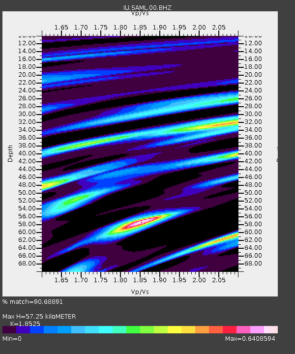
| Estimated Moho Depth: |
57.25 km |
| Estimated Crust Vp/Vs: |
1.85 |
| Assumed Crust Vp: |
6.498 km/s |
| Estimated Crust Vs: |
3.507 km/s |
| Estimated Crust Poisson's Ratio: |
0.29 |
|
| Radial Match: |
90.68891 % |
| Radial Bump: |
310 |
| Transverse Match: |
57.06926 % |
| Transverse Bump: |
400 |
| SOD ConfigId: |
823789 |
| Insert Time: |
2014-12-21 21:40:02.780 +0000 |
| GWidth: |
2.5 |
| Max Bumps: |
400 |
| Tol: |
0.001 |
|

Signal To Noise
| Channel | StoN | STA | LTA |
| IU:SAML:00:BHZ:20141207T21:23:04.519001Z | 8.107189 | 6.745686E-7 | 8.3206224E-8 |
| IU:SAML:00:BH1:20141207T21:23:04.519001Z | 9.656076 | 3.6670258E-7 | 3.7976356E-8 |
| IU:SAML:00:BH2:20141207T21:23:04.519001Z | 2.259183 | 1.5490626E-7 | 6.856738E-8 |
| Arrivals |
| Ps | 8.1 SECOND |
| PpPs | 23 SECOND |
| PsPs/PpSs | 31 SECOND |


