You are here: Home > Network List > TA - USArray Transportable Network (new EarthScope stations) Stations List
> Station E63A Oxbow, ME, USA > Earthquake Result Viewer
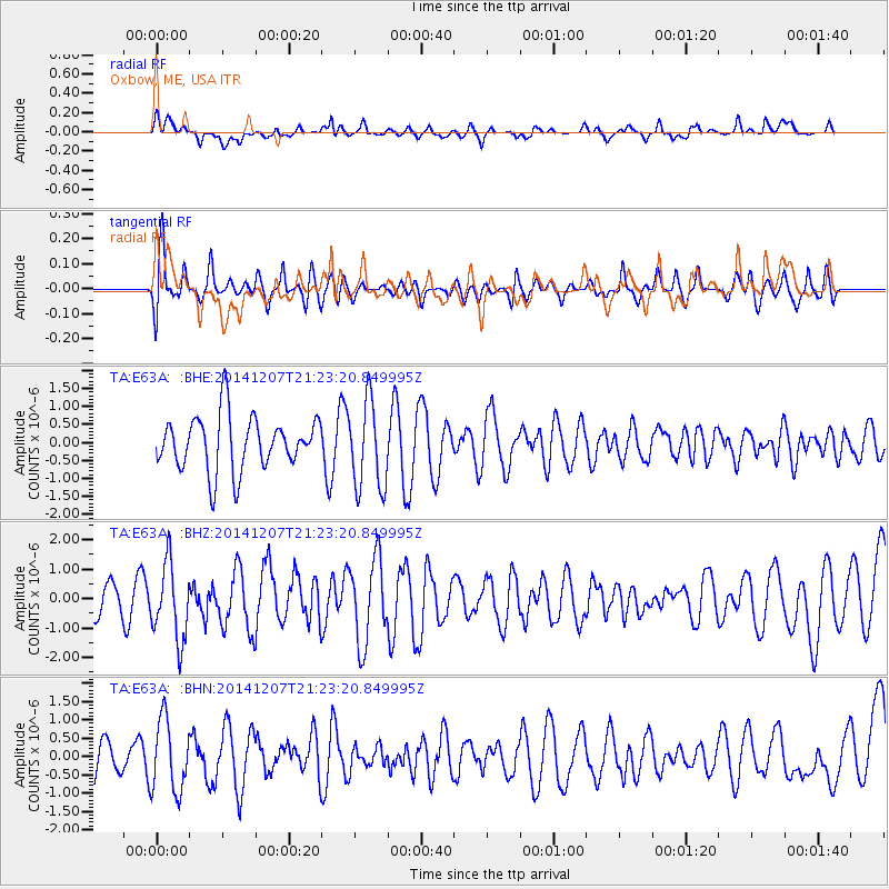
E63A Oxbow, ME, USA - Earthquake Result Viewer
*The percent match for this event was below the threshold and hence no stack was calculated.
| Earthquake location: |
Near Coast Of Guatemala |
| Earthquake latitude/longitude: |
13.7/-91.4 |
| Earthquake time(UTC): |
2014/12/07 (341) 21:16:37 GMT |
| Earthquake Depth: |
33 km |
| Earthquake Magnitude: |
5.8 MWB |
| Earthquake Catalog/Contributor: |
NEIC PDE/NEIC COMCAT |
|
| Network: |
TA USArray Transportable Network (new EarthScope stations) |
| Station: |
E63A Oxbow, ME, USA |
| Lat/Lon: |
46.42 N/68.42 W |
| Elevation: |
238 m |
|
| Distance: |
37.9 deg |
| Az: |
26.122 deg |
| Baz: |
218.206 deg |
| Ray Param: |
$rayparam |
*The percent match for this event was below the threshold and hence was not used in the summary stack. |
|
| Radial Match: |
55.56447 % |
| Radial Bump: |
400 |
| Transverse Match: |
64.909355 % |
| Transverse Bump: |
400 |
| SOD ConfigId: |
823789 |
| Insert Time: |
2014-12-21 21:46:11.033 +0000 |
| GWidth: |
2.5 |
| Max Bumps: |
400 |
| Tol: |
0.001 |
|
Signal To Noise
| Channel | StoN | STA | LTA |
| TA:E63A: :BHZ:20141207T21:23:20.849995Z | 1.1104115 | 1.2912643E-6 | 1.16287E-6 |
| TA:E63A: :BHN:20141207T21:23:20.849995Z | 2.569684 | 9.826127E-7 | 3.8238662E-7 |
| TA:E63A: :BHE:20141207T21:23:20.849995Z | 1.622128 | 1.2208045E-6 | 7.525944E-7 |
| Arrivals |
| Ps | |
| PpPs | |
| PsPs/PpSs | |


