You are here: Home > Network List > TA - USArray Transportable Network (new EarthScope stations) Stations List
> Station H17A Grant Village (NPS), Yellowstone Nt. Park, WY, USA > Earthquake Result Viewer
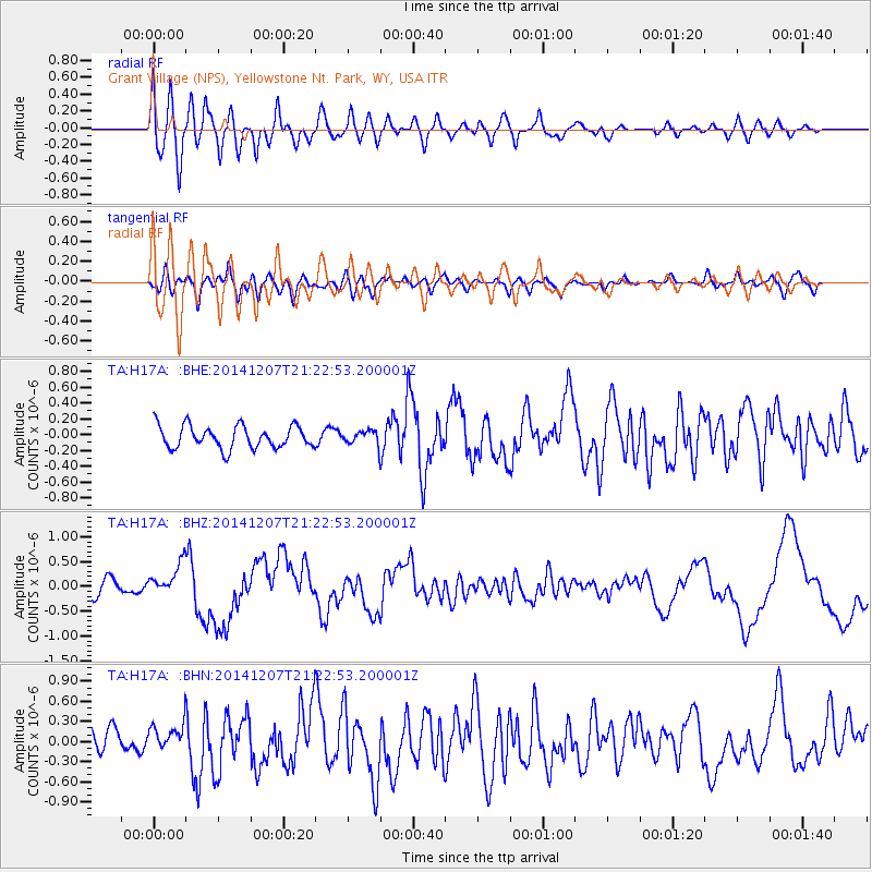
H17A Grant Village (NPS), Yellowstone Nt. Park, WY, USA - Earthquake Result Viewer
*The percent match for this event was below the threshold and hence no stack was calculated.
| Earthquake location: |
Near Coast Of Guatemala |
| Earthquake latitude/longitude: |
13.7/-91.4 |
| Earthquake time(UTC): |
2014/12/07 (341) 21:16:37 GMT |
| Earthquake Depth: |
33 km |
| Earthquake Magnitude: |
5.8 MWB |
| Earthquake Catalog/Contributor: |
NEIC PDE/NEIC COMCAT |
|
| Network: |
TA USArray Transportable Network (new EarthScope stations) |
| Station: |
H17A Grant Village (NPS), Yellowstone Nt. Park, WY, USA |
| Lat/Lon: |
44.40 N/110.58 W |
| Elevation: |
2400 m |
|
| Distance: |
34.7 deg |
| Az: |
335.585 deg |
| Baz: |
145.922 deg |
| Ray Param: |
$rayparam |
*The percent match for this event was below the threshold and hence was not used in the summary stack. |
|
| Radial Match: |
67.38216 % |
| Radial Bump: |
400 |
| Transverse Match: |
66.201996 % |
| Transverse Bump: |
400 |
| SOD ConfigId: |
823789 |
| Insert Time: |
2014-12-21 21:46:50.670 +0000 |
| GWidth: |
2.5 |
| Max Bumps: |
400 |
| Tol: |
0.001 |
|
Signal To Noise
| Channel | StoN | STA | LTA |
| TA:H17A: :BHZ:20141207T21:22:53.200001Z | 2.8538105 | 3.2627457E-7 | 1.1432944E-7 |
| TA:H17A: :BHN:20141207T21:22:53.200001Z | 1.417918 | 2.0123976E-7 | 1.4192624E-7 |
| TA:H17A: :BHE:20141207T21:22:53.200001Z | 0.618659 | 8.775691E-8 | 1.4185021E-7 |
| Arrivals |
| Ps | |
| PpPs | |
| PsPs/PpSs | |


