You are here: Home > Network List > US - United States National Seismic Network Stations List
> Station HLID Hailey, Idaho, USA > Earthquake Result Viewer
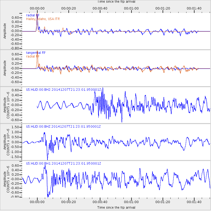
HLID Hailey, Idaho, USA - Earthquake Result Viewer
*The percent match for this event was below the threshold and hence no stack was calculated.
| Earthquake location: |
Near Coast Of Guatemala |
| Earthquake latitude/longitude: |
13.7/-91.4 |
| Earthquake time(UTC): |
2014/12/07 (341) 21:16:37 GMT |
| Earthquake Depth: |
33 km |
| Earthquake Magnitude: |
5.8 MWB |
| Earthquake Catalog/Contributor: |
NEIC PDE/NEIC COMCAT |
|
| Network: |
US United States National Seismic Network |
| Station: |
HLID Hailey, Idaho, USA |
| Lat/Lon: |
43.56 N/114.41 W |
| Elevation: |
1772 m |
|
| Distance: |
35.7 deg |
| Az: |
330.883 deg |
| Baz: |
139.421 deg |
| Ray Param: |
$rayparam |
*The percent match for this event was below the threshold and hence was not used in the summary stack. |
|
| Radial Match: |
76.44266 % |
| Radial Bump: |
400 |
| Transverse Match: |
60.74817 % |
| Transverse Bump: |
400 |
| SOD ConfigId: |
823789 |
| Insert Time: |
2014-12-21 21:50:15.924 +0000 |
| GWidth: |
2.5 |
| Max Bumps: |
400 |
| Tol: |
0.001 |
|
Signal To Noise
| Channel | StoN | STA | LTA |
| US:HLID:00:BHZ:20141207T21:23:01.950001Z | 3.7030566 | 3.972539E-7 | 1.07277295E-7 |
| US:HLID:00:BH1:20141207T21:23:01.950001Z | 2.0445554 | 2.1215999E-7 | 1.0376828E-7 |
| US:HLID:00:BH2:20141207T21:23:01.950001Z | 1.6193606 | 1.4877018E-7 | 9.1869715E-8 |
| Arrivals |
| Ps | |
| PpPs | |
| PsPs/PpSs | |


