You are here: Home > Network List > CC - Cascade Chain Volcano Monitoring Stations List
> Station PANH Panhandle Gap, Mt. Rainier, WA > Earthquake Result Viewer
PANH Panhandle Gap, Mt. Rainier, WA - Earthquake Result Viewer
| Earthquake location: |
South Of Panama |
| Earthquake latitude/longitude: |
8.0/-82.7 |
| Earthquake time(UTC): |
2014/12/08 (342) 08:54:52 GMT |
| Earthquake Depth: |
20 km |
| Earthquake Magnitude: |
6.6 MWW, 6.3 MWB, 6.7 MI |
| Earthquake Catalog/Contributor: |
NEIC PDE/NEIC COMCAT |
|
| Network: |
CC Cascade Chain Volcano Monitoring |
| Station: |
PANH Panhandle Gap, Mt. Rainier, WA |
| Lat/Lon: |
46.86 N/121.64 W |
| Elevation: |
2109 m |
|
| Distance: |
51.0 deg |
| Az: |
326.304 deg |
| Baz: |
126.8 deg |
| Ray Param: |
0.0676393 |
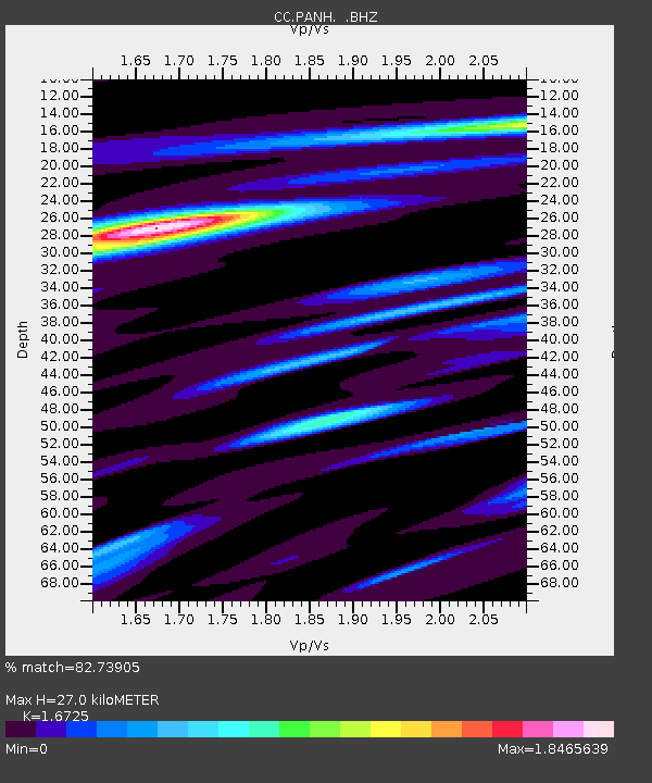
| Estimated Moho Depth: |
27.0 km |
| Estimated Crust Vp/Vs: |
1.67 |
| Assumed Crust Vp: |
6.597 km/s |
| Estimated Crust Vs: |
3.945 km/s |
| Estimated Crust Poisson's Ratio: |
0.22 |
|
| Radial Match: |
82.73905 % |
| Radial Bump: |
400 |
| Transverse Match: |
66.79301 % |
| Transverse Bump: |
400 |
| SOD ConfigId: |
824042 |
| Insert Time: |
2014-12-22 09:10:55.001 +0000 |
| GWidth: |
2.5 |
| Max Bumps: |
400 |
| Tol: |
0.001 |
|

Signal To Noise
| Channel | StoN | STA | LTA |
| CC:PANH: :BHZ:20141208T09:03:22.639999Z | 3.2085896 | 1.0376646E-6 | 3.234021E-7 |
| CC:PANH: :BHN:20141208T09:03:22.639999Z | 1.3526632 | 5.926504E-7 | 4.38136E-7 |
| CC:PANH: :BHE:20141208T09:03:22.639999Z | 1.5431107 | 7.2182206E-7 | 4.6777075E-7 |
| Arrivals |
| Ps | 2.9 SECOND |
| PpPs | 10 SECOND |
| PsPs/PpSs | 13 SECOND |


