You are here: Home > Network List > IU - Global Seismograph Network (GSN - IRIS/USGS) Stations List
> Station TIXI Tiksi, Russia > Earthquake Result Viewer
TIXI Tiksi, Russia - Earthquake Result Viewer
| Earthquake location: |
Seram, Indonesia |
| Earthquake latitude/longitude: |
-3.1/127.4 |
| Earthquake time(UTC): |
2004/01/28 (028) 22:15:30 GMT |
| Earthquake Depth: |
17 km |
| Earthquake Magnitude: |
6.0 MB, 6.5 MS, 6.7 MW, 6.6 MW |
| Earthquake Catalog/Contributor: |
WHDF/NEIC |
|
| Network: |
IU Global Seismograph Network (GSN - IRIS/USGS) |
| Station: |
TIXI Tiksi, Russia |
| Lat/Lon: |
71.65 N/128.87 E |
| Elevation: |
50 m |
|
| Distance: |
74.6 deg |
| Az: |
0.482 deg |
| Baz: |
181.519 deg |
| Ray Param: |
0.052184097 |
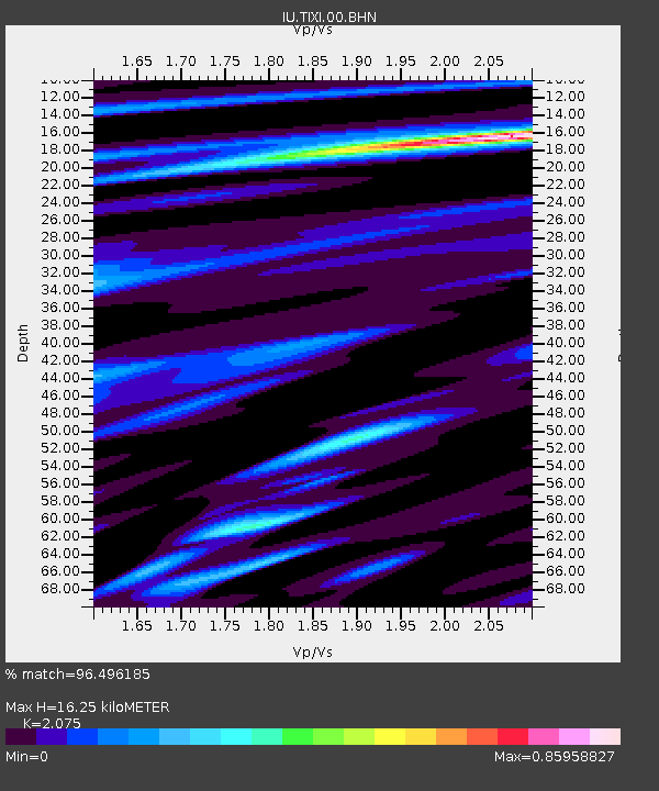
| Estimated Moho Depth: |
16.25 km |
| Estimated Crust Vp/Vs: |
2.08 |
| Assumed Crust Vp: |
6.552 km/s |
| Estimated Crust Vs: |
3.158 km/s |
| Estimated Crust Poisson's Ratio: |
0.35 |
|
| Radial Match: |
96.496185 % |
| Radial Bump: |
400 |
| Transverse Match: |
92.41043 % |
| Transverse Bump: |
400 |
| SOD ConfigId: |
2459 |
| Insert Time: |
2010-03-02 14:42:30.384 +0000 |
| GWidth: |
2.5 |
| Max Bumps: |
400 |
| Tol: |
0.001 |
|

Signal To Noise
| Channel | StoN | STA | LTA |
| IU:TIXI:00:BHN:20040128T22:26:37.61803Z | 2.5126014 | 2.0201664E-7 | 8.0401385E-8 |
| IU:TIXI:00:BHE:20040128T22:26:37.61803Z | 0.9104133 | 9.419205E-8 | 1.03460756E-7 |
| IU:TIXI:00:BHZ:20040128T22:26:37.61803Z | 4.4858446 | 5.302924E-7 | 1.1821463E-7 |
| Arrivals |
| Ps | 2.7 SECOND |
| PpPs | 7.4 SECOND |
| PsPs/PpSs | 10 SECOND |


