TIXI Tiksi, Russia - Earthquake Result Viewer
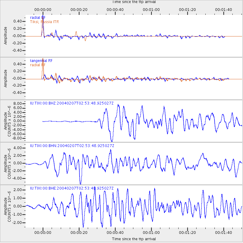
Earthquake location: Irian Jaya Region, Indonesia
Earthquake latitude/longitude: -4.0/135.0
Earthquake time(UTC): 2004/02/07 (038) 02:42:35 GMT
Earthquake Depth: 10 km
Earthquake Magnitude: 6.2 MB, 7.5 MS, 7.3 MW, 7.3 MW
Earthquake Catalog/Contributor: WHDF/NEIC
Network: IU Global Seismograph Network (GSN - IRIS/USGS)
Station: TIXI Tiksi, Russia
Lat/Lon: 71.65 N/128.87 E
Elevation: 50 m
Distance: 75.6 deg
Az: 357.99 deg
Baz: 173.659 deg
Ray Param: 0.05154763
Estimated Moho Depth: 17.5 km
Estimated Crust Vp/Vs: 1.81
Assumed Crust Vp: 6.552 km/s
Estimated Crust Vs: 3.63 km/s
Estimated Crust Poisson's Ratio: 0.28
Radial Match: 96.08874 %
Radial Bump: 322
Transverse Match: 87.50661 %
Transverse Bump: 400
SOD ConfigId: 2459
Insert Time: 2010-03-02 14:42:36.774 +0000
GWidth: 2.5
Max Bumps: 400
Tol: 0.001

Signal To Noise

ChannelStoNSTALTA
IU:TIXI:00:BHN:20040207T02:53:48.925027Z3.98605067.9768677E-72.0011957E-7
IU:TIXI:00:BHE:20040207T02:53:48.925027Z1.52888922.1487203E-71.4054127E-7
IU:TIXI:00:BHZ:20040207T02:53:48.925027Z20.8152582.224925E-61.0688914E-7
Arrivals
Ps2.2 SECOND
PpPs7.2 SECOND
PsPs/PpSs9.5 SECOND