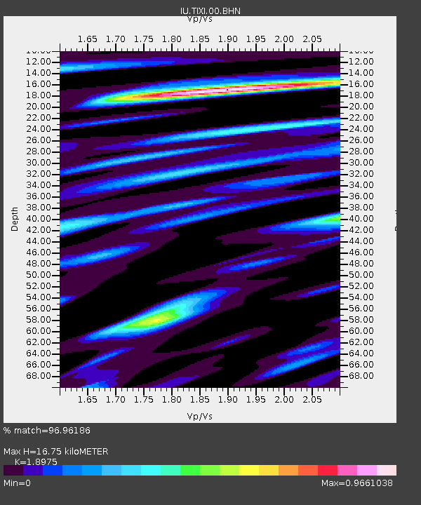
TIXI Tiksi, Russia - Earthquake Result Viewer
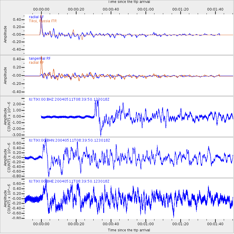
Earthquake location: Northern Sumatra, Indonesia
Earthquake latitude/longitude: 0.4/97.8
Earthquake time(UTC): 2004/05/11 (132) 08:28:48 GMT
Earthquake Depth: 21 km
Earthquake Magnitude: 5.6 MB, 6.2 MS, 6.1 MW, 6.1 MW
Earthquake Catalog/Contributor: WHDF/NEIC
Network: IU Global Seismograph Network (GSN - IRIS/USGS)
Station: TIXI Tiksi, Russia
Lat/Lon: 71.65 N/128.87 E
Elevation: 50 m
Distance: 73.8 deg
Az: 9.791 deg
Baz: 212.469 deg
Ray Param: 0.052709136
Estimated Moho Depth: 16.75 km
Estimated Crust Vp/Vs: 1.90
Assumed Crust Vp: 6.552 km/s
Estimated Crust Vs: 3.453 km/s
Estimated Crust Poisson's Ratio: 0.31
Radial Match: 96.96186 %
Radial Bump: 400
Transverse Match: 88.326904 %
Transverse Bump: 400
SOD ConfigId: 2459
Insert Time: 2010-03-02 14:43:01.714 +0000
GWidth: 2.5
Max Bumps: 400
Tol: 0.001

Signal To Noise

ChannelStoNSTALTA
IU:TIXI:00:BHN:20040511T08:39:50.123018Z13.4785024.4783437E-73.3225827E-8
IU:TIXI:00:BHE:20040511T08:39:50.123018Z3.92445643.4709416E-78.844388E-8
IU:TIXI:00:BHZ:20040511T08:39:50.123018Z13.3166081.6638757E-61.249474E-7
Arrivals
Ps2.4 SECOND
PpPs7.2 SECOND
PsPs/PpSs9.5 SECOND