You are here: Home > Network List > IU - Global Seismograph Network (GSN - IRIS/USGS) Stations List
> Station TIXI Tiksi, Russia > Earthquake Result Viewer
TIXI Tiksi, Russia - Earthquake Result Viewer
| Earthquake location: |
Timor Region |
| Earthquake latitude/longitude: |
-8.2/124.9 |
| Earthquake time(UTC): |
2004/11/11 (316) 21:26:41 GMT |
| Earthquake Depth: |
10 km |
| Earthquake Magnitude: |
6.5 MB, 7.3 MS, 7.5 MW, 7.4 MW |
| Earthquake Catalog/Contributor: |
WHDF/NEIC |
|
| Network: |
IU Global Seismograph Network (GSN - IRIS/USGS) |
| Station: |
TIXI Tiksi, Russia |
| Lat/Lon: |
71.65 N/128.87 E |
| Elevation: |
50 m |
|
| Distance: |
79.7 deg |
| Az: |
1.286 deg |
| Baz: |
184.024 deg |
| Ray Param: |
0.04879747 |
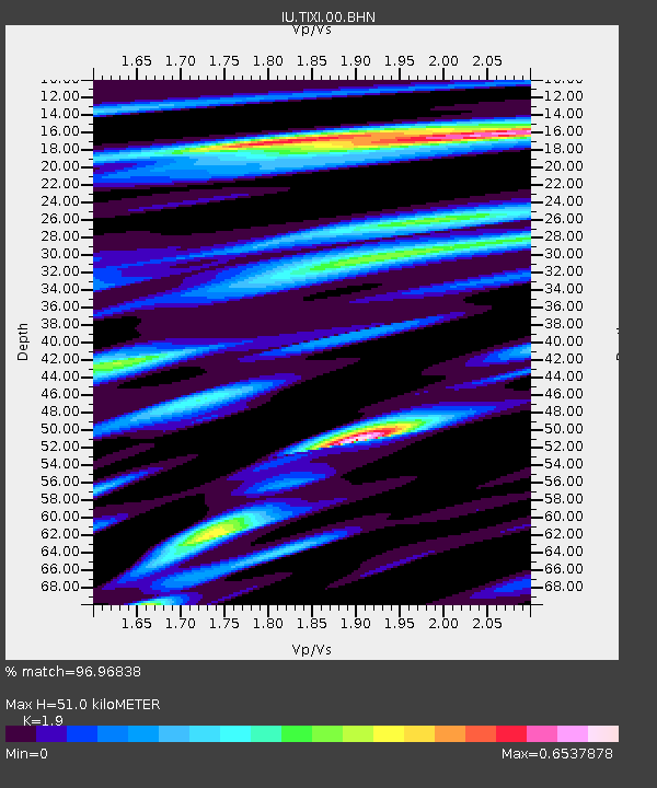
| Estimated Moho Depth: |
51.0 km |
| Estimated Crust Vp/Vs: |
1.90 |
| Assumed Crust Vp: |
6.552 km/s |
| Estimated Crust Vs: |
3.449 km/s |
| Estimated Crust Poisson's Ratio: |
0.31 |
|
| Radial Match: |
96.96838 % |
| Radial Bump: |
351 |
| Transverse Match: |
94.56516 % |
| Transverse Bump: |
400 |
| SOD ConfigId: |
2459 |
| Insert Time: |
2010-03-02 14:43:09.331 +0000 |
| GWidth: |
2.5 |
| Max Bumps: |
400 |
| Tol: |
0.001 |
|
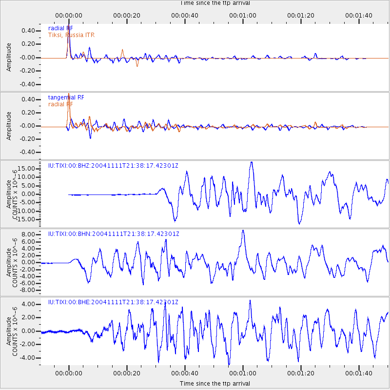
Signal To Noise
| Channel | StoN | STA | LTA |
| IU:TIXI:00:BHN:20041111T21:38:17.42301Z | 6.121765 | 7.777429E-7 | 1.2704552E-7 |
| IU:TIXI:00:BHE:20041111T21:38:17.42301Z | 2.3032942 | 1.7543556E-7 | 7.616724E-8 |
| IU:TIXI:00:BHZ:20041111T21:38:17.42301Z | 20.866587 | 2.4252424E-6 | 1.1622612E-7 |
| Arrivals |
| Ps | 7.2 SECOND |
| PpPs | 22 SECOND |
| PsPs/PpSs | 29 SECOND |


