You are here: Home > Network List > LD - Lamont-Doherty Cooperative Seismographic Network Stations List
> Station MMNY Mount Morris Dam, NY > Earthquake Result Viewer
MMNY Mount Morris Dam, NY - Earthquake Result Viewer
| Earthquake location: |
South Of Panama |
| Earthquake latitude/longitude: |
8.0/-82.7 |
| Earthquake time(UTC): |
2014/12/08 (342) 08:54:52 GMT |
| Earthquake Depth: |
20 km |
| Earthquake Magnitude: |
6.6 MWW, 6.3 MWB, 6.7 MI |
| Earthquake Catalog/Contributor: |
NEIC PDE/NEIC COMCAT |
|
| Network: |
LD Lamont-Doherty Cooperative Seismographic Network |
| Station: |
MMNY Mount Morris Dam, NY |
| Lat/Lon: |
42.73 N/77.91 W |
| Elevation: |
241 m |
|
| Distance: |
34.9 deg |
| Az: |
6.173 deg |
| Baz: |
188.311 deg |
| Ray Param: |
0.07748983 |
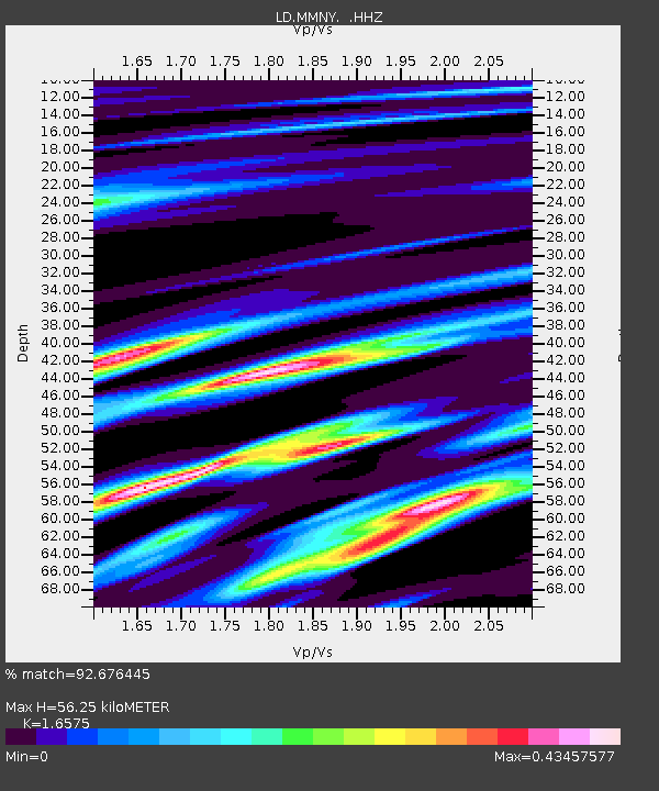
| Estimated Moho Depth: |
56.25 km |
| Estimated Crust Vp/Vs: |
1.66 |
| Assumed Crust Vp: |
6.476 km/s |
| Estimated Crust Vs: |
3.907 km/s |
| Estimated Crust Poisson's Ratio: |
0.21 |
|
| Radial Match: |
92.676445 % |
| Radial Bump: |
209 |
| Transverse Match: |
46.03469 % |
| Transverse Bump: |
400 |
| SOD ConfigId: |
824042 |
| Insert Time: |
2014-12-22 09:23:40.783 +0000 |
| GWidth: |
2.5 |
| Max Bumps: |
400 |
| Tol: |
0.001 |
|

Signal To Noise
| Channel | StoN | STA | LTA |
| LD:MMNY: :HHZ:20141208T09:01:12.115005Z | 5.1456947 | 1.9084016E-6 | 3.708735E-7 |
| LD:MMNY: :HHN:20141208T09:01:12.115005Z | 2.2866988 | 1.1809424E-6 | 5.1643985E-7 |
| LD:MMNY: :HHE:20141208T09:01:12.115005Z | 0.657709 | 2.4814992E-7 | 3.772944E-7 |
| Arrivals |
| Ps | 6.2 SECOND |
| PpPs | 21 SECOND |
| PsPs/PpSs | 27 SECOND |


