You are here: Home > Network List > LD - Lamont-Doherty Cooperative Seismographic Network Stations List
> Station MVL Millersville University, PA > Earthquake Result Viewer
MVL Millersville University, PA - Earthquake Result Viewer
| Earthquake location: |
South Of Panama |
| Earthquake latitude/longitude: |
8.0/-82.7 |
| Earthquake time(UTC): |
2014/12/08 (342) 08:54:52 GMT |
| Earthquake Depth: |
20 km |
| Earthquake Magnitude: |
6.6 MWW, 6.3 MWB, 6.7 MI |
| Earthquake Catalog/Contributor: |
NEIC PDE/NEIC COMCAT |
|
| Network: |
LD Lamont-Doherty Cooperative Seismographic Network |
| Station: |
MVL Millersville University, PA |
| Lat/Lon: |
40.00 N/76.35 W |
| Elevation: |
91 m |
|
| Distance: |
32.4 deg |
| Az: |
9.115 deg |
| Baz: |
191.786 deg |
| Ray Param: |
0.0786503 |
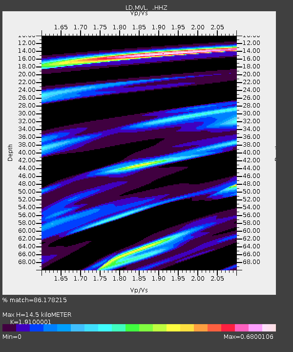
| Estimated Moho Depth: |
14.5 km |
| Estimated Crust Vp/Vs: |
1.91 |
| Assumed Crust Vp: |
6.419 km/s |
| Estimated Crust Vs: |
3.361 km/s |
| Estimated Crust Poisson's Ratio: |
0.31 |
|
| Radial Match: |
86.178215 % |
| Radial Bump: |
281 |
| Transverse Match: |
84.654564 % |
| Transverse Bump: |
400 |
| SOD ConfigId: |
824042 |
| Insert Time: |
2014-12-22 09:23:46.592 +0000 |
| GWidth: |
2.5 |
| Max Bumps: |
400 |
| Tol: |
0.001 |
|

Signal To Noise
| Channel | StoN | STA | LTA |
| LD:MVL: :HHZ:20141208T09:00:50.560012Z | 4.4877753 | 1.4498978E-6 | 3.230772E-7 |
| LD:MVL: :HHN:20141208T09:00:50.560012Z | 3.0414135 | 9.703755E-7 | 3.1905412E-7 |
| LD:MVL: :HHE:20141208T09:00:50.560012Z | 1.8480877 | 4.0733883E-7 | 2.2041098E-7 |
| Arrivals |
| Ps | 2.2 SECOND |
| PpPs | 6.1 SECOND |
| PsPs/PpSs | 8.3 SECOND |


