You are here: Home > Network List > LD - Lamont-Doherty Cooperative Seismographic Network Stations List
> Station TUPA Temple University, Pennsylvania > Earthquake Result Viewer
TUPA Temple University, Pennsylvania - Earthquake Result Viewer

| Earthquake location: |
South Of Panama |
| Earthquake latitude/longitude: |
8.0/-82.7 |
| Earthquake time(UTC): |
2014/12/08 (342) 08:54:52 GMT |
| Earthquake Depth: |
20 km |
| Earthquake Magnitude: |
6.6 MWW, 6.3 MWB, 6.7 MI |
| Earthquake Catalog/Contributor: |
NEIC PDE/NEIC COMCAT |
|
| Network: |
LD Lamont-Doherty Cooperative Seismographic Network |
| Station: |
TUPA Temple University, Pennsylvania |
| Lat/Lon: |
40.17 N/75.19 W |
| Elevation: |
112 m |
|
| Distance: |
32.8 deg |
| Az: |
10.664 deg |
| Baz: |
193.838 deg |
| Ray Param: |
0.07849692 |
| Estimated Moho Depth: |
28.5 km |
| Estimated Crust Vp/Vs: |
1.83 |
| Assumed Crust Vp: |
6.283 km/s |
| Estimated Crust Vs: |
3.434 km/s |
| Estimated Crust Poisson's Ratio: |
0.29 |
|
| Radial Match: |
84.87606 % |
| Radial Bump: |
293 |
| Transverse Match: |
59.72049 % |
| Transverse Bump: |
400 |
| SOD ConfigId: |
824042 |
| Insert Time: |
2014-12-22 09:24:08.747 +0000 |
| GWidth: |
2.5 |
| Max Bumps: |
400 |
| Tol: |
0.001 |
|
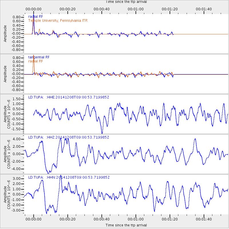
Signal To Noise
| Channel | StoN | STA | LTA |
| LD:TUPA: :HHZ:20141208T09:00:53.719985Z | 4.3819447 | 1.8613352E-6 | 4.247738E-7 |
| LD:TUPA: :HHN:20141208T09:00:53.719985Z | 4.874035 | 1.2863704E-6 | 2.639231E-7 |
| LD:TUPA: :HHE:20141208T09:00:53.719985Z | 1.6704087 | 4.8455195E-7 | 2.9007987E-7 |
| Arrivals |
| Ps | 4.0 SECOND |
| PpPs | 12 SECOND |
| PsPs/PpSs | 16 SECOND |


