You are here: Home > Network List > N4 - Central and EAstern US Network Stations List
> Station U38B Mount Pleasant Farm, Gravette, AR, USA > Earthquake Result Viewer
U38B Mount Pleasant Farm, Gravette, AR, USA - Earthquake Result Viewer
| Earthquake location: |
South Of Panama |
| Earthquake latitude/longitude: |
8.0/-82.7 |
| Earthquake time(UTC): |
2014/12/08 (342) 08:54:52 GMT |
| Earthquake Depth: |
20 km |
| Earthquake Magnitude: |
6.6 MWW, 6.3 MWB, 6.7 MI |
| Earthquake Catalog/Contributor: |
NEIC PDE/NEIC COMCAT |
|
| Network: |
N4 Central and EAstern US Network |
| Station: |
U38B Mount Pleasant Farm, Gravette, AR, USA |
| Lat/Lon: |
36.44 N/94.39 W |
| Elevation: |
389 m |
|
| Distance: |
30.3 deg |
| Az: |
341.089 deg |
| Baz: |
156.542 deg |
| Ray Param: |
0.07936154 |
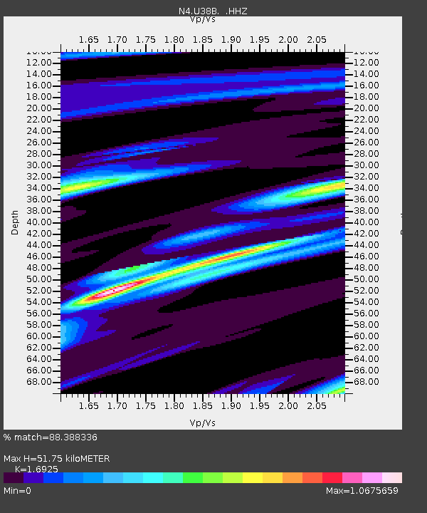
| Estimated Moho Depth: |
51.75 km |
| Estimated Crust Vp/Vs: |
1.69 |
| Assumed Crust Vp: |
6.53 km/s |
| Estimated Crust Vs: |
3.858 km/s |
| Estimated Crust Poisson's Ratio: |
0.23 |
|
| Radial Match: |
88.388336 % |
| Radial Bump: |
251 |
| Transverse Match: |
55.765953 % |
| Transverse Bump: |
400 |
| SOD ConfigId: |
824042 |
| Insert Time: |
2014-12-22 09:26:31.177 +0000 |
| GWidth: |
2.5 |
| Max Bumps: |
400 |
| Tol: |
0.001 |
|

Signal To Noise
| Channel | StoN | STA | LTA |
| N4:U38B: :HHZ:20141208T09:00:31.969985Z | 5.906228 | 1.7941003E-6 | 3.0376412E-7 |
| N4:U38B: :HHN:20141208T09:00:31.969985Z | 7.471725 | 1.309028E-6 | 1.7519756E-7 |
| N4:U38B: :HHE:20141208T09:00:31.969985Z | 3.2785463 | 6.7007073E-7 | 2.0438044E-7 |
| Arrivals |
| Ps | 6.0 SECOND |
| PpPs | 20 SECOND |
| PsPs/PpSs | 26 SECOND |


