You are here: Home > Network List > TA - USArray Transportable Network (new EarthScope stations) Stations List
> Station G63A Kingsbury, ME, USA > Earthquake Result Viewer
G63A Kingsbury, ME, USA - Earthquake Result Viewer
| Earthquake location: |
South Of Panama |
| Earthquake latitude/longitude: |
8.0/-82.7 |
| Earthquake time(UTC): |
2014/12/08 (342) 08:54:52 GMT |
| Earthquake Depth: |
20 km |
| Earthquake Magnitude: |
6.6 MWW, 6.3 MWB, 6.7 MI |
| Earthquake Catalog/Contributor: |
NEIC PDE/NEIC COMCAT |
|
| Network: |
TA USArray Transportable Network (new EarthScope stations) |
| Station: |
G63A Kingsbury, ME, USA |
| Lat/Lon: |
45.11 N/69.62 W |
| Elevation: |
363 m |
|
| Distance: |
38.7 deg |
| Az: |
14.844 deg |
| Baz: |
200.999 deg |
| Ray Param: |
0.075383075 |
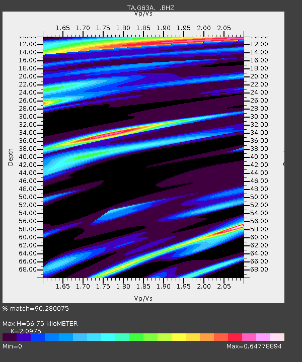
| Estimated Moho Depth: |
56.75 km |
| Estimated Crust Vp/Vs: |
2.10 |
| Assumed Crust Vp: |
6.419 km/s |
| Estimated Crust Vs: |
3.06 km/s |
| Estimated Crust Poisson's Ratio: |
0.35 |
|
| Radial Match: |
90.280075 % |
| Radial Bump: |
375 |
| Transverse Match: |
69.14644 % |
| Transverse Bump: |
400 |
| SOD ConfigId: |
824042 |
| Insert Time: |
2014-12-22 09:35:55.028 +0000 |
| GWidth: |
2.5 |
| Max Bumps: |
400 |
| Tol: |
0.001 |
|

Signal To Noise
| Channel | StoN | STA | LTA |
| TA:G63A: :BHZ:20141208T09:01:44.625015Z | 2.7008653 | 2.0475766E-6 | 7.5811874E-7 |
| TA:G63A: :BHN:20141208T09:01:44.625015Z | 1.869435 | 1.7698432E-6 | 9.4672623E-7 |
| TA:G63A: :BHE:20141208T09:01:44.625015Z | 0.9709981 | 4.7704737E-7 | 4.912959E-7 |
| Arrivals |
| Ps | 10 SECOND |
| PpPs | 26 SECOND |
| PsPs/PpSs | 36 SECOND |


