You are here: Home > Network List > TA - USArray Transportable Network (new EarthScope stations) Stations List
> Station G64A Maxfield, ME, USA > Earthquake Result Viewer
G64A Maxfield, ME, USA - Earthquake Result Viewer
| Earthquake location: |
South Of Panama |
| Earthquake latitude/longitude: |
8.0/-82.7 |
| Earthquake time(UTC): |
2014/12/08 (342) 08:54:52 GMT |
| Earthquake Depth: |
20 km |
| Earthquake Magnitude: |
6.6 MWW, 6.3 MWB, 6.7 MI |
| Earthquake Catalog/Contributor: |
NEIC PDE/NEIC COMCAT |
|
| Network: |
TA USArray Transportable Network (new EarthScope stations) |
| Station: |
G64A Maxfield, ME, USA |
| Lat/Lon: |
45.25 N/68.76 W |
| Elevation: |
165 m |
|
| Distance: |
39.1 deg |
| Az: |
15.666 deg |
| Baz: |
202.25 deg |
| Ray Param: |
0.07517917 |
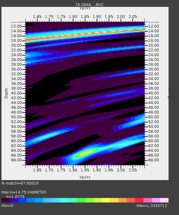
| Estimated Moho Depth: |
14.75 km |
| Estimated Crust Vp/Vs: |
1.88 |
| Assumed Crust Vp: |
6.419 km/s |
| Estimated Crust Vs: |
3.419 km/s |
| Estimated Crust Poisson's Ratio: |
0.30 |
|
| Radial Match: |
87.80819 % |
| Radial Bump: |
353 |
| Transverse Match: |
61.975555 % |
| Transverse Bump: |
400 |
| SOD ConfigId: |
824042 |
| Insert Time: |
2014-12-22 09:35:58.645 +0000 |
| GWidth: |
2.5 |
| Max Bumps: |
400 |
| Tol: |
0.001 |
|

Signal To Noise
| Channel | StoN | STA | LTA |
| TA:G64A: :BHZ:20141208T09:01:47.574996Z | 2.5201175 | 2.040004E-6 | 8.0948763E-7 |
| TA:G64A: :BHN:20141208T09:01:47.574996Z | 1.7117586 | 1.0314822E-6 | 6.025862E-7 |
| TA:G64A: :BHE:20141208T09:01:47.574996Z | 0.7960056 | 9.0878456E-7 | 1.1416811E-6 |
| Arrivals |
| Ps | 2.2 SECOND |
| PpPs | 6.2 SECOND |
| PsPs/PpSs | 8.3 SECOND |


