You are here: Home > Network List > TA - USArray Transportable Network (new EarthScope stations) Stations List
> Station H60A Morristown, VT, USA > Earthquake Result Viewer
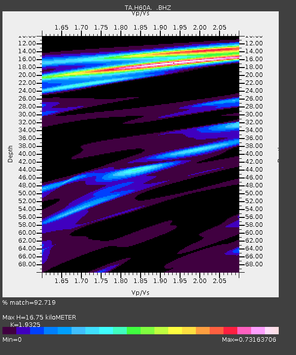
H60A Morristown, VT, USA - Earthquake Result Viewer
| Earthquake location: |
South Of Panama |
| Earthquake latitude/longitude: |
8.0/-82.7 |
| Earthquake time(UTC): |
2014/12/08 (342) 08:54:52 GMT |
| Earthquake Depth: |
20 km |
| Earthquake Magnitude: |
6.6 MWW, 6.3 MWB, 6.7 MI |
| Earthquake Catalog/Contributor: |
NEIC PDE/NEIC COMCAT |
|
| Network: |
TA USArray Transportable Network (new EarthScope stations) |
| Station: |
H60A Morristown, VT, USA |
| Lat/Lon: |
44.56 N/72.70 W |
| Elevation: |
459 m |
|
| Distance: |
37.5 deg |
| Az: |
11.767 deg |
| Baz: |
196.413 deg |
| Ray Param: |
0.07609106 |
| Estimated Moho Depth: |
16.75 km |
| Estimated Crust Vp/Vs: |
1.93 |
| Assumed Crust Vp: |
6.419 km/s |
| Estimated Crust Vs: |
3.322 km/s |
| Estimated Crust Poisson's Ratio: |
0.32 |
|
| Radial Match: |
92.719 % |
| Radial Bump: |
285 |
| Transverse Match: |
75.93593 % |
| Transverse Bump: |
400 |
| SOD ConfigId: |
824042 |
| Insert Time: |
2014-12-22 09:36:21.712 +0000 |
| GWidth: |
2.5 |
| Max Bumps: |
400 |
| Tol: |
0.001 |
|

Signal To Noise
| Channel | StoN | STA | LTA |
| TA:H60A: :BHZ:20141208T09:01:34.275009Z | 3.0184343 | 2.065223E-6 | 6.842034E-7 |
| TA:H60A: :BHN:20141208T09:01:34.275009Z | 2.6286604 | 1.5806066E-6 | 6.012974E-7 |
| TA:H60A: :BHE:20141208T09:01:34.275009Z | 1.2028042 | 5.3358184E-7 | 4.4361485E-7 |
| Arrivals |
| Ps | 2.6 SECOND |
| PpPs | 7.2 SECOND |
| PsPs/PpSs | 9.8 SECOND |


